tóng-àn:Amt Vioel in NF.PNG
Lohankhapedia (自由的百科全書) 欲共你講..。
跳至導覽
跳至搜尋
Amt_Vioel_in_NF.PNG (353 × 340 像素,檔案佔量: 7 KB,MIME類型: image/png)
|
|
這是對Wikimedia Commons引來的一份檔案。伊佇hia ê kì-su̍t-ia̍h頂面的資訊顯示對下底. |

|
Siū-khuân hōo lí i-tsiàu Tsū-iû Nńg-thé Ki-kim-huē huat-pòo ê bô kòo-tīng bûn-jī, hong-bīn bûn-jī kah hong-té bûn-jīGNU Tsū-iû Bûn-kiānn Siū-khuân Tiâu-khuán1.2 pán ia̍h-sī koh-lâi ê jīm-ì pán-pún, tuì pún tóng-àn tsìn-hîng hok-tsè, thuân-pòo, kah/ia̍h-sī siu-kái.Tsit-ê hia̍p-gī ê hù-pún khǹg tī GNU Tsū-iû Bûn-kiānn Siū-khuân Tiâu-khuán tang-tiong.http://www.gnu.org/copyleft/fdl.htmlGFDLGNU Free Documentation Licensetruetrue |
| Tsit-ê tóng-àn sī iōng Tshòng-iōng CC Kâng-khuán hong-sik hun-hióng 3.0 bī tsāi-tuē pán-pún siū-khuân tiâu-khuán. | ||
| ||
| 已新增授權條款標題至此檔案,作為GFDL授權更新的一部份。http://creativecommons.org/licenses/by-sa/3.0/CC BY-SA 3.0Creative Commons Attribution-Share Alike 3.0truetrue |
Khài-iàu
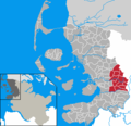
- en: This map shows the area of the Amt (group of municipalities) de:Amt Viöl in the Kreis (district) Nordfriesland, Schleswig-Holstein, Germany.
- de: Diese Karte zeigt das Gebiet des Amts Viöl im Kreis Nordfriesland, Schleswig-Holstein, Deutschland.
- en: The map was created by de:Benutzer:Rauenstein.
- de: Die Karte wurde von de:Benutzer:Rauenstein erstellt.
- en: Location marked by de:Benutzer:Begw.
- de: Position durch de:Benutzer:Begw markiert.
說明
添加單行說明來描述出檔案所代表的內容
在此檔案描寫的項目
描繪內容 繁體中文
授權條款 繁體中文
GNU自由文檔許可證1.2或更高版本 繁體中文
多媒體型式 繁體中文
image/png
資料大小 繁體中文
7,564 Byte
高度 繁體中文
340 ōe-sò͘
寬度 繁體中文
353 ōe-sò͘
檔案歷史
揤日期/時間,看彼時陣的檔案.
| 日期/ 時間 | 細張圖 | 寸尺 | 用者 | 註解 | |
|---|---|---|---|---|---|
| 現在 | 2007年1月21日 (禮拜) 20:15 |  | 353 × 340(7 KB) | wikimediacommons>Ditschi | Corrections in Klanxbüll and Rodenäs, Reußenköge and Ockholm |
影像連結
以下的頁連到這个影像: