tóng-àn:Caspian Sea from orbit.jpg
跳至導覽
跳至搜尋


先看佔量: 471 × 599 像素. 其他的 kái-sek-tō͘: 188 × 240 像素 | 377 × 480 像素 | 471 × 600 像素 | 603 × 768 像素 | 804 × 1,024 像素 | 4,400 × 5,600 像素.
全解析度 (4,400 × 5,600 像素,檔案佔量: 3.44 MB,MIME類型: image/jpeg)
|
|
這是對Wikimedia Commons引來的一份檔案。伊佇hia ê kì-su̍t-ia̍h頂面的資訊顯示對下底. |
Khài-iàu
| Soat-bêng |
العربية: منظرٌ من مدار الأرض لِبحر قزوين. التعليق الأصلي: كما أوردته وكالة الناسا: ::"القسم الشمالي من بحر قزوين يُعاني من ظاهرةٍ تُعرف باسم التخثث أو إغناء الماء، وهي تلك الحالة التي تتسببُ فيها الأسمدة الزراعيَّة المُنسابة من خِلال مياه الري والأمطار بِنُمو الطحالب في المياه. يُؤدي نُفوق وتحلُّل تلك الطحالب إلى حرمان المياه من الأكسجين، ممَّا يُؤدي بِدوره إلى الإضرار بِالحياة البريَّة بِطبيعة الحال. هذه الصُورة لِبحر قزوين تُظهرُ بعض الدوَّامات الخضراء والزرقاء على مقرُبةٍ من مصب نهر الڤولغا (أعلى الوسط)، ممَّا يدُل على وُجود كميَّةٍ من الطحالب. اللون الأزرق اللامع في القسم الشمالي الشرقي من البحر قد يكون تولَّد نتيجة اختلاط بعض النباتات بِالترسُبات، نظرًا لِأنَّ هذا الموقع هو أكثر المناطق ضُحولةً في البحر.
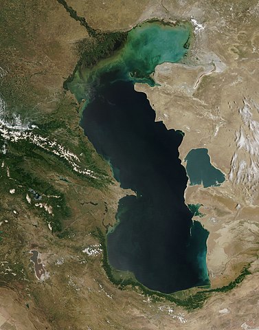
English: This is a view from orbit of the Caspian Sea as imaged by the MODIS sensor on the Terra satellite. Caption: The original caption from NASA: ::"The northern part of the Caspian Sea is plagued by a process called eutrophication, in which agricultural run-off rich in fertilizers stimulates rampant growth of algae in the water. The death and decay of these algae robs the water of oxygen, with obvious negative consequences for aquatic life. This image of the Caspian Sea shows swirls of green and blue near the mouth of the Volga River (top center), which indicate the presence of algae. The bright blue color of the northeastern part of the sea may be due to a mixture of plant life and sediment, for this is where the sea is most shallow. This image is from the Moderate Resolution Imaging Spectroradiometer (MODIS) on the Terra satellite on June 11, 2003.
Español: El Mar Caspio visto desde la órbita terrestre
فارسی: تصویر ماهوارهای از دریای خزر
Тоҷикӣ: Тасвири Баҳр Каспӣ аз осмон |
| Ji̍t-kî | |
| Chhut-chhù |
http://visibleearth.nasa.gov/view_rec.php?id=5514
|
| Chok-chiá | Jeff Schmaltz, MODIS Rapid Response Team, NASA/GSFC |
| 其他版本 | 此檔案衍生的作品: Caspian Sea from orbit-NoRedLines.jpg |
|

|
根據最有價值圖像標準,這張圖像被評定为在Satellite images of the Caspian Sea範疇內最有價值的共享資源圖像。你可以在Commons:Valued image candidates/Caspian Sea from orbit.jpg参看它的提名。 |
Siū-khoân
| 本作品由NASA創作,屬於公有領域。根據NASA的版權政策:“NASA的創作除非另有聲明否則不受版權保護。”(參見:Template:PD-USGov/zh,NASA版權政策或JPL圖像使用政策) | ||
 |
警告:
|
檔案歷史
揤日期/時間,看彼時陣的檔案.
| 日期/ 時間 | 細張圖 | 寸尺 | 用者 | 註解 | |
|---|---|---|---|---|---|
| 現在 | 2010年6月14日 (拜1) 17:16 | | 4,400 × 5,600(3.44 MB) | Originalwana | higher res |
影像連結
以下的頁連到這个影像: