tóng-àn:Eurozone.svg
跳至導覽
跳至搜尋


此 SVG 檔案的 PNG 預覽的大小:450 × 456 像素。 其他的 kái-sek-tō͘: 237 × 240 像素 | 474 × 480 像素 | 592 × 600 像素 | 758 × 768 像素 | 1,011 × 1,024 像素.
全解析度 (SVG ùng-giông, chék-cháung: 450 × 456 chuông-só, ùng-giông duâi-nâung:417 KB)
|
|
這是對Wikimedia Commons引來的一份檔案。伊佇hia ê kì-su̍t-ia̍h頂面的資訊顯示對下底. |
Khài-iàu
| Soat-bêng |
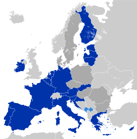
Deutsch: Eurozone
Staaten, die den Euro de jure angenommen haben Staaten und Gebiete, die den Euro de facto angenommen haben EU-Mitglieder außerhalb der Eurozone English: Eurozone
Countries using the Euro de jure Countries and territories using the Euro de facto EU member states that are outside the Eurozone Français : Zone euro
Pays ayant adopté l'euro de jure Pays et territoires utilisant l'euro de facto États membres de l'Union européenne n'ayant pas adopté l'euro Hrvatski: Eurozona
Članice Eurozone Države koje koriste Euro kao sredstvo plaćanja, ali su izvan Eurozone i Europske unije (Kosovo i Crna Gora) Članice Europske unije koje su izvan Eurozone Latviešu: Eirozona
Valstis, kuras izmanto eiro de jure Valstis un teritorijas, kuras izmanto eiro de facto Eiropas savienības dalībvalstis ārpus eirozonas Polski: Strefa Euro
Kraje używające Euro de jure Kraje i terytoria używające Euro de facto Członkowie Unii Europejskiej będący poza strefą Euro Português: Zona Euro
Países que adotaram de jure o euro Países e territórios que utilizam de facto o euro Estados-membros da União Europeia que não adotaram o euro Српски / srpski: Еврозона
Чланице еврозоне Државе и области, које користе Евро као средство плаћања, али су ван Еврозоне и Европске уније (Црна Гора и Косово) Чланице Европске уније, које су ван Еврозоне Українська: Єврозона
Країни, що використовують Євро де-юре Країни та території, що використовують Євро де-факто Країни-члени ЄС за межами єврозони فارسی: منطقه یورو
کشورهایی که یورو را به طور رسمی پذیرفتهاند کشورها و مناطقی که از یورو به عنوان وسیله پرداخت استفاده می کنند اما عضو منطقه یورو نیستند کشورهای عضو اتحادیه اروپا که خارج از منطقه یورو هستند |
| Ji̍t-kî | |
| Chhut-chhù | Europe countries.svg |
| Chok-chiá | Glentamara |
| SVG開發 |
Siū-khoân
| 我,此作品的版權所有人,釋出此作品至公共領域。此授權條款在全世界均適用。 這可能在某些國家不合法,如果是的話: 我授予任何人有權利使用此作品於任何用途,除受法律約束外,不受任何限制。 |
檔案歷史
揤日期/時間,看彼時陣的檔案.
| 日期/ 時間 | 細張圖 | 寸尺 | 用者 | 註解 | |
|---|---|---|---|---|---|
| 現在 | 2023年3月2日 (拜4) 13:47 | | 450 × 456(417 KB) | Discombobulates | Unify Cyrpus, recognised by the EU as one state |
影像連結
無半頁連到這張影像.