這是一份對Wikimedia Commons引來的檔案

tóng-àn:Haitang 2005-07-17 0825Z.jpg

Lohankhapedia (自由的百科全書) 欲共你講..。
跳至導覽 跳至搜尋

全解析度(1,280 × 948 像素,檔案佔量: 308 KB,MIME類型: image/jpeg

Khài-iàu

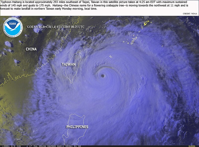
Soat-bêng Typhoon Haitang is located approximately 293 miles southeast of Taipei, Taiwan in this satellite picture taken at 4:25 EDT with maximum sustained winds of 145 mph and gusts to 175 mph. Haitang--the Chinese name for a flowering crabapple tree--is moving towards the northwest at 11 mph is forecast to make landfall in northern Taiwan early Monday morning, local time.
Ji̍t-kî
Chhut-chhù http://www.osei.noaa.gov/Events/Tropical/W_Pacific/2005/TRCHaitang198_G9.jpg
Chok-chiá NOAA / Operational Significant Event Imagery
Siū-khuân ún-tsún
(Koh iōng tsit-ê tóng-àn)
Public domain
本圖像屬於公有領域,因該作品最初來自於美國國家海洋和大氣管理局職員的職務作品。

العربية  čeština  Deutsch  Zazaki  English  español  eesti  suomi  français  hrvatski  magyar  italiano  日本語  한국어  македонски  മലയാളം  Plattdüütsch  Nederlands  polski  português  română  русский  sicilianu  slovenščina  Türkçe  Tiếng Việt  简体中文  繁體中文  +/−

The NOAA emblem is the property of the U.S. Government and a trademark of the United States Department of Commerce.

說明

添加單行說明來描述出檔案所代表的內容

在此檔案描寫的項目

描繪內容 繁體中文

著作權狀態 繁體中文

公有領域 繁體中文

管轄區 繁體中文: Bí-kok
斷定方法 繁體中文: 美國聯邦政府的作品 繁體中文

檔案歷史

揤日期/時間,看彼時陣的檔案.

日期/ 時間細張圖寸尺用者註解
現在2005年7月18日 (拜1) 11:272005年7月18日 (拜1) 11:27版本的細圖1,280 × 948(308 KB)wikimediacommons>KaurJmeb07/17/2005 8:25 UTC海棠颱風位置。<BR>圖片來源:http://www.osei.noaa.gov/ {{PD}}

無半頁連到這張影像.

元資料