tóng-àn:Lac du Bourget (entier).JPG
跳至導覽
跳至搜尋

先看佔量: 798 × 600 像素. 其他的 kái-sek-tō͘: 320 × 240 像素 | 639 × 480 像素 | 1,022 × 768 像素 | 1,280 × 962 像素 | 2,560 × 1,924 像素 | 2,832 × 2,128 像素.
全解析度 (2,832 × 2,128 像素,檔案佔量: 1.12 MB,MIME類型: image/jpeg)
|
|
這是對Wikimedia Commons引來的一份檔案。伊佇hia ê kì-su̍t-ia̍h頂面的資訊顯示對下底. |
.JPG)
Khài-iàu
| Soat-bêng | |
| Ji̍t-kî | |
| Chhut-chhù | Ka-tī chò--ê |
| Chok-chiá | Florian Pépellin |
| Siū-khuân ún-tsún (Koh iōng tsit-ê tóng-àn) |
CC-BY-SA 3.0 |
| 拍攝地點 | | 位於此地的本圖片與其他圖片: OpenStreetMap |
|---|
.JPG¶ms=045.632528_N_0005.950194_E_globe:Earth_type:camera__&language=nan)
Siū-khoân
我,本作品的著作權持有者,決定用以下授權條款發佈本作品:
Tsit-ê tóng-àn sī iōng Tshòng-iōng CC Kâng-khuán hong-sik hun-hióng 3.0 bī tsāi-tuē pán-pún siū-khuân tiâu-khuán.
- Lí ē-sái tsū-iû:
- hun-hióng – kho͘-pih, hoat-pò͘ kap thoân-pò͘ pún chok
- tiông-sin siu-kái – kái-pian pún chok-phín
- Àn i-hā ê tiâu-kiāⁿ
- Piau-sī miâ-sìnn – Lí ài siá-bîng tsìng-khak ê miâ-hō, ū siū-khuân tiâu-khuán ê liân-kiat, iáu-koh-ū lí tsuè siánn-mih ê kái-piàn. Lí ē-tàng tī jīm-hô ha̍p-lí ê hong-sik tsìn-hîng, m̄-kò buē-tàng ti̍t-tsiap kóng siū-khuân hōo lí ia̍h-sī lí sú-iōng.
- Kâng-khuán hong-sik hun-hióng – Lí nā kái-tōng, piàn-khoán, he̍k-chiá kun-kù pún chok chhòng-chō, lí kaⁿ-taⁿ ē-tàng ēng kap pún chok kâng-khoán he̍k-chiá saⁿ-chhiūⁿ ê hí-khó lâi hoat-pò͘ chò--chhut-lâi ê chok-phín.
檔案歷史
揤日期/時間,看彼時陣的檔案.
| 日期/ 時間 | 細張圖 | 寸尺 | 用者 | 註解 | |
|---|---|---|---|---|---|
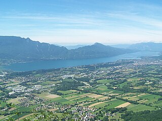
| 現在 | 2007年7月1日 (禮拜) 20:34 | | 2,832 × 2,128(1.12 MB) | wikimediacommons>Floflo | {{Information |Description=The entire Lake of Bourget, the biggest natural lake of France (Savoie). |Source=Own work |Date=June, 29th 2007 |Author=Florian P. Floflo |Permission=Public domain |other_versions= }} [[Category:Lac du B |
影像連結
以下的頁連到這个影像:
.JPG)