這是一份對Wikimedia Commons引來的檔案

tóng-àn:Verbandsgemeinde Kirner Land in KH.svg

Lohankhapedia (自由的百科全書) 欲共你講..。
跳至導覽 跳至搜尋

全解析度(SVG ùng-giông, chék-cháung: 276 × 276 chuông-só, ùng-giông duâi-nâung:210 KB)

Khài-iàu

Soat-bêng
Deutsch (de): Lagekarte von Verbandsgemeinde Kirner Land, Landkreis Bad Kreuznach, Rheinland-Pfalz, Deutschland.
English (en): Locator map of Verbandsgemeinde Kirner Land in District of Bad Kreuznach, Rhineland-Palatinate, Germany.
français (fr): Plan de localisation de la municipalité Verbandsgemeinde Kirner Land dans l'Arrondissement de Bad Kreuznach dans Rhénanie-Palatinat, Allemagne.
hornjoserbsce (hsb): Poziciska karta gmejny Verbandsgemeinde Kirner Land, Landkreis Bad Kreuznach, Rheinland-Pfalz, Němska.
македонски (mk): Положбена карта на Verbandsgemeinde Kirner Land во рамките на Landkreis Bad Kreuznach, Rheinland-Pfalz, Германија.
Nederlands (nl): Detailkaart van Verbandsgemeinde Kirner Land in de Landkreis Bad Kreuznach, Rheinland-Pfalz, Duitsland.
Esperanto (eo): Situomapo de Verbandsgemeinde Kirner Land en Landkreis Bad Kreuznach, Rheinland-Pfalz, Germanio.
മലയാളം (ml): ജർമ്മനിയിലെ Rhineland-Palatinate, District of Bad Kreuznach, Verbandsgemeinde Kirner Land ഭൂപടസ്ഥാനം.
Ji̍t-kî
Chhut-chhù 我個人以下列物件為基礎來創作: Verbandsgemeinde Stromberg in KH.svg  Hagar66
Chok-chiá NordNordWest
其他版本 参看 Locator maps of municipalities in Landkreis Bad Kreuznach

Siū-khoân

Usage of this file with:

explanatory notes: Legally binding is only the full legalcode. For a free usage I recommend to respect the following licence conditions:
1. Provide my name as given above: NordNordWest,
2. a copy of, or the URI for, the applicable license: https://creativecommons.org/licenses/by-sa/3.0/de/legalcode,
3. the title of the work,
4. in the case of an adaptation, a credit identifying the use of the work in the adaptation.
This license and the rights granted hereunder will terminate automatically upon any breach by you of the terms of this license. Any of the above conditions can be waived if you get permission from the copyright holder. If you have questions or wish differing conditions, please contact me through nnwest@t-online.de or my discussion page

w:zh:創用CC
Piau-sī miâ-sìnn Kâng-khuán hong-sik hun-hióng
Piau-sī miâ-sìnn: Karte: NordNordWest, Lizenz: Creative Commons by-sa-3.0 de
Lí ē-sái tsū-iû:
  • hun-hióng – kho͘-pih, hoat-pò͘ kap thoân-pò͘ pún chok
  • tiông-sin siu-kái – kái-pian pún chok-phín
Àn i-hā ê tiâu-kiāⁿ
  • Piau-sī miâ-sìnn – Lí ài siá-bîng tsìng-khak ê miâ-hō, ū siū-khuân tiâu-khuán ê liân-kiat, iáu-koh-ū lí tsuè siánn-mih ê kái-piàn. Lí ē-tàng tī jīm-hô ha̍p-lí ê hong-sik tsìn-hîng, m̄-kò buē-tàng ti̍t-tsiap kóng siū-khuân hōo lí ia̍h-sī lí sú-iōng.
  • Kâng-khuán hong-sik hun-hióng – Lí nā kái-tōng, piàn-khoán, he̍k-chiá kun-kù pún chok chhòng-chō, lí kaⁿ-taⁿ ē-tàng ēng kap pún chok kâng-khoán he̍k-chiá saⁿ-chhiūⁿ ê hí-khó lâi hoat-pò͘ chò--chhut-lâi ê chok-phín.

說明

添加單行說明來描述出檔案所代表的內容

在此檔案描寫的項目

描繪內容 繁體中文

著作權狀態 繁體中文

有著作權 繁體中文

多媒體型式 繁體中文

image/svg+xml

資料大小 繁體中文

215,424 Byte

高度 繁體中文

276 ōe-sò͘

寬度 繁體中文

276 ōe-sò͘

校驗和 繁體中文

61f78359f4eab255291cf9b1fe3c549953d3621f

斷定方法 繁體中文: SHA-1 中文 (已轉換拼寫)

檔案歷史

揤日期/時間,看彼時陣的檔案.

日期/ 時間細張圖寸尺用者註解
現在2019年6月22日 (拜6) 08:142019年6月22日 (拜6) 08:14版本的細圖276 × 276(210 KB)wikimediacommons>NordNordWest
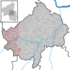
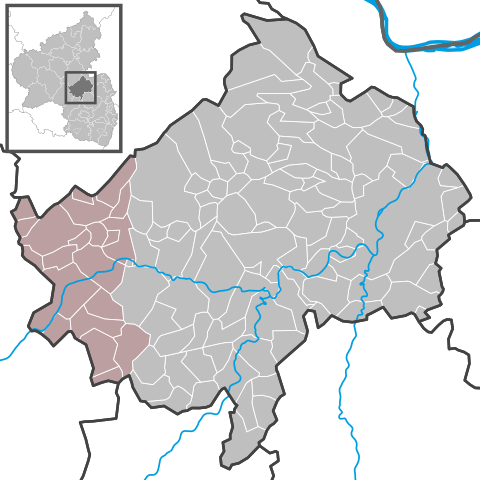
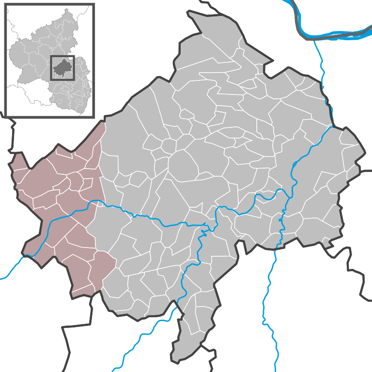
{{Information |Description= {{DeLocMaps |mun=Verbandsgemeinde Kirner Land |munlink= |lk=Landkreis Bad Kreuznach |land=Rheinland-Pfalz |enlk=District of Bad Kreuznach |enlklink=Bad Kreuznach (district) |frlk=l'Arrondissement de Bad Kreuznach |frlklink=Arrondissement de Bad Kreuznach |enland=Rhineland-Palatinate |enlandlink=Rhineland-Palatinate |frland=Rhénanie-Palatinat |frlandlink=Rhénanie-Palatinat }} |source={{Own based|Verbandsgemeinde Stromberg in KH.svg|by=Hagar66}} |date=2019-06-22 |aut...

以下的頁連到這个影像:

元資料