tóng-àn:Юрактау - panoramio.jpg
跳至導覽
跳至搜尋


先看佔量: 800 × 521 像素. 其他的 kái-sek-tō͘: 320 × 209 像素 | 640 × 417 像素 | 1,024 × 667 像素 | 1,280 × 834 像素 | 1,679 × 1,094 像素.
全解析度 (1,679 × 1,094 像素,檔案佔量: 422 KB,MIME類型: image/jpeg)
|
|
這是對Wikimedia Commons引來的一份檔案。伊佇hia ê kì-su̍t-ia̍h頂面的資訊顯示對下底. |
Khài-iàu
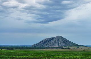
| Soat-bêng | Юрактау | ||
| Ji̍t-kî | 攝於2012年5-goe̍h28日 | ||
| Chhut-chhù | https://web.archive.org/web/20161025030129/http://www.panoramio.com/photo/73059546 | ||
| Chok-chiá | Konstantin Tsibin | ||
| 授權允准 (Bô siŏh-huòi sāi ciā ùng-giông) |
此檔案採用創用CC 姓名標示 3.0 未在地化版本授權條款。 Biĕu-sê miàng-sáng: Konstantin Tsibin
|
||
| Tags (from Panoramio photo page) | Sterlitamaksky District, гора, Стерлитамак, Юрактау |
| 拍攝地點 | | 位於此地的本圖片與其他圖片: OpenStreetMap |
|---|
檔案歷史
揤日期/時間,看彼時陣的檔案.
| 日期/ 時間 | 細張圖 | 寸尺 | 用者 | 註解 | |
|---|---|---|---|---|---|
| 現在 | 2017年1月6日 (拜5) 03:35 | | 1,679 × 1,094(422 KB) | Panoramio upload bot | == {{int:filedesc}} == {{Information |description=Юрактау |date={{Taken on|2012-05-28}} |source=http://www.panoramio.com/photo/73059546 |author=[http://www.panoramio.com/user/6704018?with_photo_id=73059546 Konstantin Tsibin] |permission={{cc-by-... |
影像連結
以下的頁連到這个影像: