tóng-àn:Blair County Courthouse Apr 10.JPG
跳至導覽
跳至搜尋


先看佔量: 800 × 600 像素. 其他的 kái-sek-tō͘: 320 × 240 像素 | 640 × 480 像素 | 1,024 × 768 像素 | 1,280 × 960 像素 | 2,592 × 1,944 像素.
全解析度 (2,592 × 1,944 像素,檔案佔量: 655 KB,MIME類型: image/jpeg)
|
|
這是對Wikimedia Commons引來的一份檔案。伊佇hia ê kì-su̍t-ia̍h頂面的資訊顯示對下底. |
| 目標地點 | | 位於此地的本圖片與其他圖片: OpenStreetMap |
|---|
| Soat-bêng |
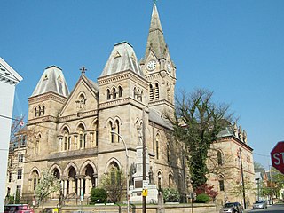
English: Blair County Courthouse, April 2010 |
||
| Ji̍t-kî | (UTC) | ||
| Chhut-chhù | Ka-tī chò--ê (Original text: I (Pubdog (talk)) created this work entirely by myself.) | ||
| Chok-chiá | Pubdog (talk) | ||
| 授權允准 (Bô siŏh-huòi sāi ciā ùng-giông) |
|
原始上傳日誌
The original description page was here. All following user names refer to en.wikipedia.
- 2010-04-11 19:11 Pubdog 2592×1944 (765572 bytes) {{Information |Description = Blair County Courthouse, April 2010 |Source = I (~~~) created this work entirely by myself. |Date = ~~~~~ |Author = ~~~ |other_versions = }}
- 2010-04-11 19:13 Pubdog 2592×1944 (670670 bytes) straighten
檔案歷史
揤日期/時間,看彼時陣的檔案.
| 日期/ 時間 | 細張圖 | 寸尺 | 用者 | 註解 | |
|---|---|---|---|---|---|
| 現在 | 2011年10月15日 (拜6) 17:03 | | 2,592 × 1,944(655 KB) | BotMultichill | {{BotMoveToCommons|en.wikipedia|year={{subst:CURRENTYEAR}}|month={{subst:CURRENTMONTHNAME}}|day={{subst:CURRENTDAY}}}} == {{int:filedesc}} == {{Information |description={{en|1=Blair County Courthouse, April 2010}} |date=19:11, 11 April 2010 (UTC) |source |
影像連結
以下的頁連到這个影像: