tóng-àn:Borneo Topography.png
跳至導覽
跳至搜尋


先看佔量: 567 × 600 像素. 其他的 kái-sek-tō͘: 227 × 240 像素 | 454 × 480 像素 | 726 × 768 像素 | 968 × 1,024 像素 | 1,725 × 1,824 像素.
全解析度 (1,725 × 1,824 像素,檔案佔量: 2.52 MB,MIME類型: image/png)
|
|
這是對Wikimedia Commons引來的一份檔案。伊佇hia ê kì-su̍t-ia̍h頂面的資訊顯示對下底. |
Khài-iàu
| Soat-bêng |
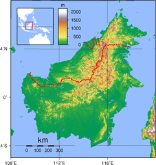
English: Relief (hypsometric) map of Borneo. Red lines represent national borders between Indonesia (south), Malaysia (north), and Brunei (top north). Created with GMT from publicly released GLOBE data[1]. For locator version, see File:Borneo Locator Topography.png.
Français : Carte du relief de l'île de Borneo. Les lignes rouges représentent les frontières séparant les états se partageant l'île de Bornéo : L'Indonésie (au sud), la Malaisie (au nord de l'Indonésie) et l'état de Bruneï (au nord de la Malaisie). Image produite à l'aide de la suite logicielle GMT à partir des données publiques GLOBE. Une version locator est disponible. |
| Ji̍t-kî | |
| Chhut-chhù | Ka-tī chò--ê |
| Chok-chiá | Sadalmelik |

|
根據最有價值圖像標準,這張圖像被評定为在Hypsometric map of Borneo範疇內最有價值的共享資源圖像。你可以在Commons:Valued image candidates/Borneo Topography.png参看它的提名。 |
Siū-khoân
| 我,此作品的版權所有人,釋出此作品至公共領域。此授權條款在全世界均適用。 這可能在某些國家不合法,如果是的話: 我授予任何人有權利使用此作品於任何用途,除受法律約束外,不受任何限制。 |
檔案歷史
揤日期/時間,看彼時陣的檔案.
| 日期/ 時間 | 細張圖 | 寸尺 | 用者 | 註解 | |
|---|---|---|---|---|---|
| 現在 | 2007年9月2日 (禮拜) 03:17 | | 1,725 × 1,824(2.52 MB) | Sadalmelik | Better data, better colours |
影像連結
以下的頁連到這个影像: