tóng-àn:Brunei and Muara mukims.png
跳至導覽
跳至搜尋
無較權的解析度.
Brunei_and_Muara_mukims.png (696 × 565 像素,檔案佔量: 97 KB,MIME類型: image/png)
|
|
這是對Wikimedia Commons引來的一份檔案。伊佇hia ê kì-su̍t-ia̍h頂面的資訊顯示對下底. |
| Soat-bêng |
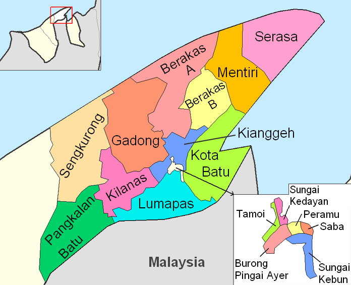
English: Map of the mukims of Brunei and Muara district in Brunei. Created by Rarelibra 21:51, 11 September 2006 (UTC) for public domain use, using MapInfo Professional v8.5 and various mapping resources. |
| Ji̍t-kî | 2006年9-goe̍h11日 (原始上傳日期) |
| Chhut-chhù | Transferred from en.wikipedia to Commons by Hanhil using CommonsHelper. |
| Chok-chiá | 英文Wikipedia的Rarelibra |
Siū-khoân
| 此作品已由其作者,英文Wikipedia的Rarelibra,釋出至公有領域。此授權條款在全世界均適用。 這可能在某些國家不合法,如果是的話: Rarelibra授予任何人有權利使用此作品於任何用途,除受法律約束外,不受任何限制。 |
原始上傳日誌
The original description page was here. All following user names refer to en.wikipedia.
- 2006-09-11 21:51 Rarelibra 1056×816× (32325 bytes) Map of the mukims of Brunei and Muara district in Brunei. Created by ~~~~ for public domain use, using MapInfo Professional v8.5 and various mapping resources.
檔案歷史
揤日期/時間,看彼時陣的檔案.
| 日期/ 時間 | 細張圖 | 寸尺 | 用者 | 註解 | |
|---|---|---|---|---|---|
| 現在 | 2011年2月27日 (禮拜) 01:27 | | 696 × 565(97 KB) | Naturals | color + change size and type of font |
影像連結
以下的頁連到這个影像:
- Berakas A Kūn (Brunei-Muara)
- Berakas B Kūn (Brunei-Muara)
- Burong Pingai Ayer Kūn (Brunei-Muara)
- Gadong A Kūn (Brunei-Muara)
- Gadong B Kūn (Brunei-Muara)
- Kianggeh Kūn (Brunei-Muara)
- Kilanas Kūn (Brunei-Muara)
- Kota Batu Kūn (Brunei-Muara)
- Lumapas Kūn (Brunei-Muara)
- Mentiri Kūn (Brunei-Muara)
- Pengkalan Batu Kūn (Brunei-Muara)
- Peramu Kūn (Brunei-Muara)
- Saba Kūn (Brunei-Muara)
- Sengkurong Kūn (Brunei-Muara)
- Serasa Kūn (Brunei-Muara)
- Sungai Kebun Kūn (Brunei-Muara)
- Sungai Kedayan Kūn (Brunei-Muara)
- Tamoi Kūn (Brunei-Muara)