tóng-àn:Coconino County incorporated areas Williams highlighted.svg
跳至導覽
跳至搜尋


此 SVG 檔案的 PNG 預覽的大小:500 × 600 像素。 其他的 kái-sek-tō͘: 200 × 240 像素 | 400 × 480 像素 | 640 × 768 像素 | 853 × 1,024 像素 | 700 × 840 像素.
全解析度 (SVG ùng-giông, chék-cháung: 700 × 840 chuông-só, ùng-giông duâi-nâung:59 KB)
|
|
這是對Wikimedia Commons引來的一份檔案。伊佇hia ê kì-su̍t-ia̍h頂面的資訊顯示對下底. |
Khài-iàu
| Soat-bêng |
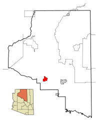
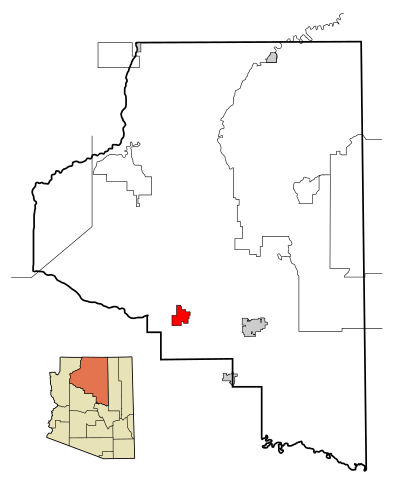
This map shows the incorporated areas and Indian reservations in Coconino County, Arizona.
|
| Ji̍t-kî | |
| Chhut-chhù | My own work, based on public domain information. Based on similar map concepts by Ixnayonthetimmay |
| Chok-chiá | Arkyan |
| 授權允准 (Bô siŏh-huòi sāi ciā ùng-giông) |
Copyleft-type licensing. See below. |
| 其他版本 | See Category:Maps of Coconino County for other versions of this image. |
Siū-khoân
我,本作品的著作權持有者,決定用以下授權條款發佈本作品:

|
已授權您依據自由軟體基金會發行的無固定段落、封面文字和封底文字GNU自由文件授權條款1.2版或任意後續版本,對本檔進行複製、傳播和/或修改。該協議的副本列在GNU自由文件授權條款中。 |
| 此檔案採用創用CC 姓名標示-相同方式分享 3.0 未在地化版本授權條款。 | ||
| ||
| 已新增授權條款標題至此檔案,作為GFDL授權更新的一部份。 |
- 你會使自由:
- 分享 – kho͘-pih, hoat-pò͘ kap thoân-pò͘ pún chok
- 重新修改 – kái-pian pún chok-phín
- Àn i-hā ê tiâu-kiāⁿ
- 標示名姓 – 您必須指名出正確的製作者,和提供授權條款的連結,以及表示是否有對內容上做出變更。您可以用任何合理的方式來行動,但不得以任何方式表明授權條款是對您許可或是由您所使用。
- 仝款方式方享 – Lí nā kái-tōng, piàn-khoán, he̍k-chiá kun-kù pún chok chhòng-chō, lí kaⁿ-taⁿ ē-tàng ēng kap pún chok kâng-khoán he̍k-chiá saⁿ-chhiūⁿ ê hí-khó lâi hoat-pò͘ chò--chhut-lâi ê chok-phín.
Nṳ̄ buóh dĭk sié-nó̤h sêu-guòng dèu-kuāng dŭ kō̤-ī gēng.
檔案歷史
揤日期/時間,看彼時陣的檔案.
| 日期/ 時間 | 細張圖 | 寸尺 | 用者 | 註解 | |
|---|---|---|---|---|---|
| 現在 | 2007年3月22日 (拜4) 07:06 | | 700 × 840(59 KB) | Shereth | {{Information |Description=This map shows the incorporated areas and Indian reservations in Coconino County, Arizona, highlighting Williams in red. I created it |
影像連結
以下的頁連到這个影像: