tóng-àn:Cold War alliances mid-1975.svg
跳至導覽
跳至搜尋


此 SVG 檔案的 PNG 預覽的大小:800 × 409 像素。 其他的 kái-sek-tō͘: 320 × 164 像素 | 640 × 327 像素 | 1,024 × 524 像素 | 1,280 × 655 像素 | 860 × 440 像素.
全解析度 (SVG ùng-giông, chék-cháung: 860 × 440 chuông-só, ùng-giông duâi-nâung:1.36 MB)
|
|
這是對Wikimedia Commons引來的一份檔案。伊佇hia ê kì-su̍t-ia̍h頂面的資訊顯示對下底. |
Khài-iàu
| Soat-bêng |
Dansk: Et simplificeret kort over den Kolde Krigs alliancer, som de så ud mellem 30. april og 24. juni 1975. De sovjetiske og kinesiske blokke er gruppet sammen af illustrative årsager, men under den repræsenterede tidsperiode var de ikke allierede. Den grå region udgjorde ikke en alliance, men indeholder derimod alle de lande, der ikke var allierede med Sovjetunionen, USA, eller Kina. Dette kort er baseret på File:First second third worlds map.svg, men er ændret til at vise en gruppering af lande der kan bekræftes og præcist afspejler titen af GFS [1].
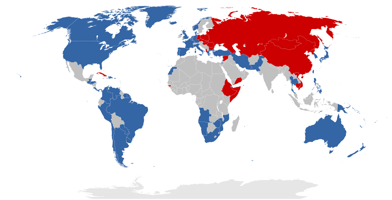
English: A simplified map of the Cold War alliances between 30 April and 24 June 1975. The Soviet and Chinese blocs are grouped together as one for illustrative purposes, but note that historically they were not allied during the time represented. The grey region does not represent an alliance, but rather encompasses all countries that were not aligned with the Soviet Union, the USA, or China. This map is based on File:First second third worlds map.svg, but it is modified to display a grouping of countries that is verifiable and accurately reflects the caption of Three Worlds.
Rationale:
Eastern-aligned:
Nederlands: Een vereenvoudigde kaart van de bondgenootschappen tussen 30 april en 24 juni 1975. De Sovjet en Chinese blokken zijn gegroepeerd voor illustratieve doeleinden, maar merk op dat, historisch gezien, ze geen bondgenootschap hadden in die tijdsperiode. De grijs regio stelt geen bondgenootschap voor, maar voegt eerder alle landen samen die geen banden hadden met de Sovjet-Unie, de VS of China. Deze kaart is gebaseerd op File:First second third worlds map.svg, maar ze is aangepast om de landen weer te geven die tot de Eerste, Tweede of Derde Wereld behoren [2]. |
| Ji̍t-kî | |
| Chhut-chhù | Ka-tī chò--ê |
| Chok-chiá | Vorziblix |
Siū-khoân
我,本作品的著作權持有者,決定用以下授權條款發佈本作品:
| 此檔案在創用CC CC0 1.0 通用公有領域貢獻宣告之下分發。 | |
| 在此宣告之下分發本作品者,已依據各國著作權法,在全世界放棄其對本作品所擁有的著作權及所有相關相似的法律權利,從而將本作品貢獻至公有領域。您可以複製、修改、分發和演示該作品,用於任何商業用途,所有這些都不需要請求授權。
|
檔案歷史
揤日期/時間,看彼時陣的檔案.
| 日期/ 時間 | 細張圖 | 寸尺 | 用者 | 註解 | |
|---|---|---|---|---|---|
| 現在 | 2023年12月2日 (拜6) 02:53 | | 860 × 440(1.36 MB) | Human Transistor | Guinea-Bissau and Cambodia were colored red. They were Communist states at this time. |
影像連結
以下的頁連到這个影像: