tóng-àn:Corinne Methodist Episcopal Church.jpg
跳至導覽
跳至搜尋


先看佔量: 474 × 600 像素. 其他的 kái-sek-tō͘: 190 × 240 像素 | 379 × 480 像素 | 607 × 768 像素 | 809 × 1,024 像素 | 3,584 × 4,535 像素.
全解析度 (3,584 × 4,535 像素,檔案佔量: 1.7 MB,MIME類型: image/jpeg)
|
|
這是對Wikimedia Commons引來的一份檔案。伊佇hia ê kì-su̍t-ia̍h頂面的資訊顯示對下底. |
| 拍攝地點 | | 位於此地的本圖片與其他圖片: OpenStreetMap |
|---|
| Soat-bêng |
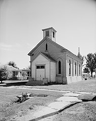
English: Front of the Corinne Methodist Episcopal Church, located at the intersection of Coronado and South 600 Streets in Corinne, Utah, United States. Built in 1870, it is listed on the National Register of Historic Places. |
|||||
| Ji̍t-kî | ||||||
| Chhut-chhù | Library of Congress, Prints and Photograph Division HABS: UTAH,2-CORI,1-2 | |||||
| Chok-chiá | P. Kent Fairbanks | |||||
| 授權允准 (Bô siŏh-huòi sāi ciā ùng-giông) |
|


|
|
檔案歷史
揤日期/時間,看彼時陣的檔案.
| 日期/ 時間 | 細張圖 | 寸尺 | 用者 | 註解 | |
|---|---|---|---|---|---|
| 現在 | 2009年5月23日 (拜6) 16:50 | | 3,584 × 4,535(1.7 MB) | Cropbot | upload cropped version, operated by User:Finavon. Summary: border cropped |
影像連結
以下的頁連到這个影像: