tóng-àn:ElectoralCollege2012.svg
跳至導覽
跳至搜尋


此 SVG 檔案的 PNG 預覽的大小:800 × 465 像素。 其他的 kái-sek-tō͘: 320 × 186 像素 | 640 × 372 像素 | 1,024 × 595 像素 | 1,280 × 744 像素 | 1,020 × 593 像素.
全解析度 (SVG ùng-giông, chék-cháung: 1,020 × 593 chuông-só, ùng-giông duâi-nâung:29 KB)
|
|
這是對Wikimedia Commons引來的一份檔案。伊佇hia ê kì-su̍t-ia̍h頂面的資訊顯示對下底. |
Khài-iàu
| U.S. presidential election maps (SVG) |
| See also: National Atlas maps (png) |
|
1789 · 1792 · 1796 · 1800 · 1804 · 1808 · 1812 · 1816 · 1820 · 1824 · 1828 · 1832 · 1836 · 1840 · 1844 · 1848 · 1852 · 1856 · 1860 · 1864 · 1868 · 1872 · 1876 · 1880 · 1884 · 1888 · 1892 · 1896 · 1900 · 1904 · 1908 · 1912 · 1916 · 1920 · 1924 · 1928 · 1932 · 1936 · 1940 · 1944 · 1948 · 1952 · 1956 · 1960 · 1964 · 1968 · 1972 · 1976 · 1980 · 1984 · 1988 · 1992 · 1996 · 2000 · 2004 · 2008 · 2012 · 2016 · 2020 · 2024 |
| Soat-bêng |
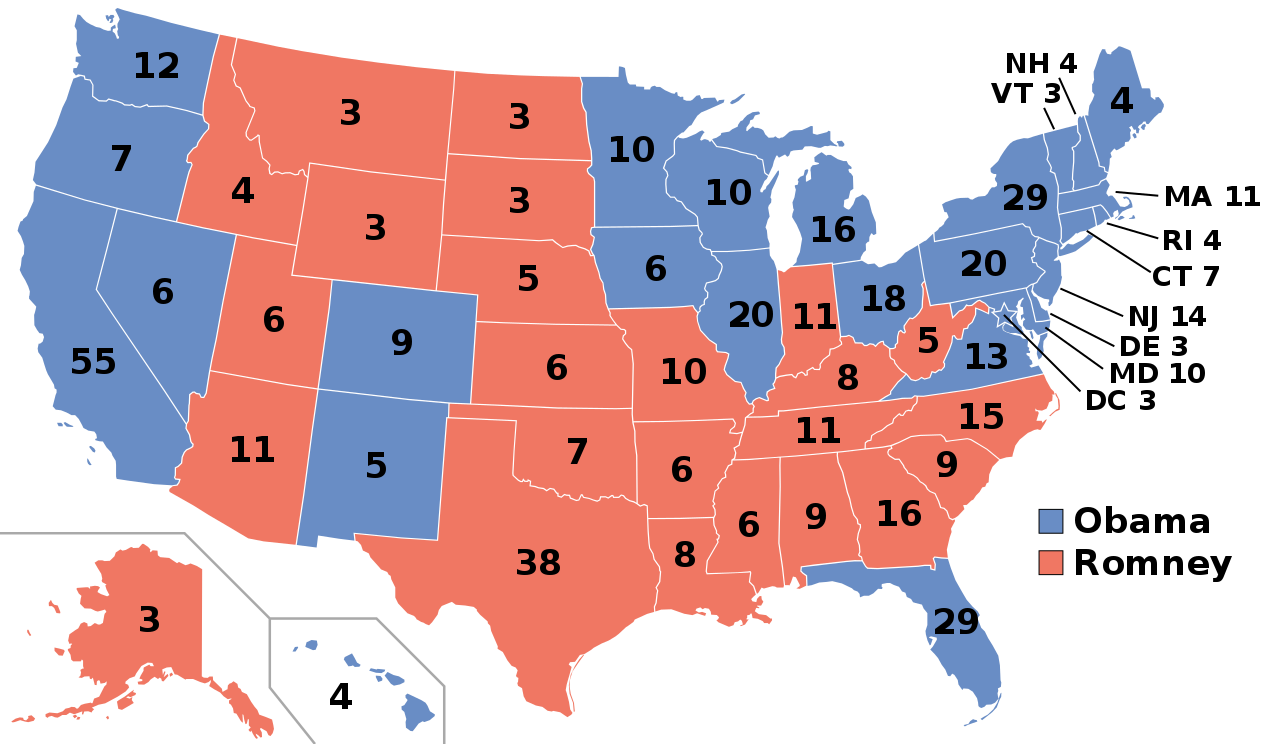
English: Electoral college map for the 2012 United States presidential election (note: Nebraska and Maine split their EVs by congressional district).
Sources used: Pollster.com, CNN.com, MSNBC.com, AP.org, and FOXNews.com |
||
| Ji̍t-kî | |||
| Chhut-chhù | Ka-tī chò--ê | ||
| Chok-chiá | Gage | ||
| 授權允准 (Bô siŏh-huòi sāi ciā ùng-giông) |
|
||
| 其他版本 |
Electoral College 2012.svg: |
||
| SVG開發 |
檔案歷史
揤日期/時間,看彼時陣的檔案.
| 日期/ 時間 | 細張圖 | 寸尺 | 用者 | 註解 | |
|---|---|---|---|---|---|
| 現在 | 2018年11月20日 (拜2) 10:55 | | 1,020 × 593(29 KB) | Newfraferz87 | Simplify further: coordinates & fills, following this |
.svg)
影像連結
以下的頁連到這个影像: