tóng-àn:Enceladus from Voyager.jpg
跳至導覽
跳至搜尋


先看佔量: 600 × 600 像素. 其他的 kái-sek-tō͘: 240 × 240 像素 | 480 × 480 像素 | 1,004 × 1,004 像素.
全解析度 (1,004 × 1,004 像素,檔案佔量: 93 KB,MIME類型: image/jpeg)
|
|
這是對Wikimedia Commons引來的一份檔案。伊佇hia ê kì-su̍t-ia̍h頂面的資訊顯示對下底. |
Khài-iàu
Siū-khoân
| Soat-bêng |
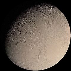
English: This color Voyager 2 image mosaic shows the water-ice-covered surface of Enceladus, one of Saturn's icy moons. Enceladus' diameter of just 500 km would fit across the state of Arizona, yet despite its small size Enceladus exhibits one of the most interesting surfaces of all the icy satellites. Enceladus reflects about 90% of the incident sunlight (about like fresh-fallen snow), placing it among the most reflective objects in the Solar System. Several geologic terrains have superposed crater densities that span a factor of at least 500, thereby indicating huge differences in the ages of these terrains. It is possible that the high reflectivity of Enceladus' surface results from continuous deposition of icy particles from Saturn's E-ring, which in fact may originate from icy volcanoes on Enceladus' surface. Some terrains are dominated by sinuous mountain ridges from 1 to 2 km high (3300 to 6600 feet), whereas other terrains are scarred by linear cracks, some of which show evidence for possible sideways fault motion such as that of California's infamous San Andreas fault. Some terrains appear to have formed by separation of icy plates along cracks, and other terrains are exceedingly smooth at the resolution of this image. The implication carried by Enceladus' surface is that this tiny ice ball has been geologically active and perhaps partially liquid in its interior for much of its history. The heat engine that powers geologic activity here is thought to be elastic deformation caused by tides induced by Enceladus' orbital motion around Saturn and the motion of another moon, Dione. |
| Ji̍t-kî | |
| Chhut-chhù | http://photojournal.jpl.nasa.gov/catalog/PIA00347 |
| Chok-chiá | NASA/JPL/USGS |
| 此標籤不表示文件的著作權狀態。任何文件在附有此標籤的同時還需要一個有效的著作權標籤。請參閱許可協議說明頁面以了解更多資訊。 其他語言:
|
Siū-khoân
| 本作品由NASA創作,屬於公有領域。根據NASA的版權政策:“NASA的創作除非另有聲明否則不受版權保護。”(參見:Template:PD-USGov/zh,NASA版權政策或JPL圖像使用政策) | ||
 |
警告:
|
檔案歷史
揤日期/時間,看彼時陣的檔案.
| 日期/ 時間 | 細張圖 | 寸尺 | 用者 | 註解 | |
|---|---|---|---|---|---|
| 現在 | 2005年3月17日 (拜4) 19:20 | | 1,004 × 1,004(93 KB) | Bricktop | NASA image |
影像連結
以下的頁連到這个影像: