tóng-àn:EnglandCheshireEast.png
跳至導覽
跳至搜尋
無較權的解析度.
EnglandCheshireEast.png (200 × 247 像素,檔案佔量: 25 KB,MIME類型: image/png)
|
|
這是對Wikimedia Commons引來的一份檔案。伊佇hia ê kì-su̍t-ia̍h頂面的資訊顯示對下底. |
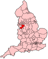
| Soat-bêng | Map showing location of Cheshire East Unitary Authority (effective 1st April 2009) in England. |
| Ji̍t-kî | |
| Chhut-chhù | Own work, derived from File:BlankMap-EnglandSubdivisions2009.png. |
| Chok-chiá | Keith Edkins |
Siū-khoân
| 此檔案採用創用CC 姓名標示-相同方式分享 3.0 未在地化版本授權條款。 受免責聲明的約束。 | ||
| ||
| 已新增授權條款標題至此檔案,作為GFDL授權更新的一部份。 |

|
已授權您依據自由軟體基金會發行的無固定段落、封面文字和封底文字GNU自由文件授權條款1.2版或任意後續版本,對本檔進行複製、傳播和/或修改。該協議的副本列在GNU自由文件授權條款中。 受免責聲明的約束。 |
檔案歷史
揤日期/時間,看彼時陣的檔案.
| 日期/ 時間 | 細張圖 | 寸尺 | 用者 | 註解 | |
|---|---|---|---|---|---|
| 現在 | 2009年3月12日 (拜4) 17:39 | | 200 × 247(25 KB) | Keith Edkins | {{Information |Description=Map showing location of Cheshire East Unitary Authority (effective 1st April 2009) in England. |Source=Own work, derived from File:BlankMap-EnglandSubdivisions2009.png. |Date=12 March 2009 |Author=[[User:Keith Edkins|Keith |
影像連結
以下的頁連到這个影像: