這是一份對Wikimedia Commons引來的檔案

tóng-àn:Europe map Napoleon 1811.svg

Lohankhapedia (自由的百科全書) 欲共你講..。
跳至導覽 跳至搜尋

全解析度(SVG ùng-giông, chék-cháung: 415 × 422 chuông-só, ùng-giông duâi-nâung:89 KB)

Khài-iàu

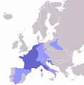
Soat-bêng Map of the w:First French Empire and satellite states, with w:1811 borders. Created by User:OwenBlacker from Image:Europe blank map.png, therefore they are the source.
Ji̍t-kî (UTC)
Chhut-chhù
Chok-chiá
其他版本 File:Europe map Napoleon 1811.png

Siū-khoân

Public domain 我,此作品的版權所有人,釋出此作品至公共領域。此授權條款在全世界均適用。
這可能在某些國家不合法,如果是的話:
我授予任何人有權利使用此作品於任何用途,除受法律約束外,不受任何限制。

原始上傳日誌

This image is a derivative work of the following images:

  • File:Europe_map_Napoleon_1811.png licensed with PD-self
    • 2006-10-16T00:53:12Z Deltabeignet 415x422 (13615 Bytes) Corrected status of Illyrian provinces.
    • 2005-08-21T00:51:11Z OwenBlacker 415x422 (11762 Bytes) Map of the [[w:First French Empire]] and satellite states, with [[w:1811]] borders. Created by [[User:OwenBlacker]] from [[:Image:Europe blank map.png]] {{GFDL}} {{cc-by-sa-2.0-uk}}

Uploaded with derivativeFX

Annotations
InfoField
This image is annotated: View the annotations at Commons

說明

添加單行說明來描述出檔案所代表的內容

在此檔案描寫的項目

描繪內容 繁體中文

檔案歷史

揤日期/時間,看彼時陣的檔案.

日期/ 時間細張圖寸尺用者註解
現在2009年5月2日 (拜6) 23:142009年5月2日 (拜6) 23:14版本的細圖415 × 422(89 KB)wikimediacommons>Mnmazur{{Information |Description=Map of the w:First French Empire and satellite states, with w:1811 borders. Created by User:OwenBlacker from Image:Europe blank map.png, therefore they are the source. |Source=*[[:File:Europe_map_Napoleon_1811.p

以下的頁連到這个影像: