tóng-àn:Glendora, California (7134837923).jpg

全解析度 (1,600 × 1,063 像素,檔案佔量: 666 KB,MIME類型: image/jpeg)
|
|
這是對Wikimedia Commons引來的一份檔案。伊佇hia ê kì-su̍t-ia̍h頂面的資訊顯示對下底. |
Khài-iàu
| Soat-bêngGlendora, California (7134837923).jpg |
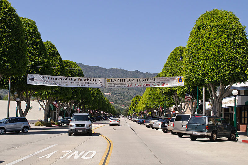
Looking north from Civic Center along Glendora Avenue, which is the historical shopping area that still is home to mom-and-pop stores. I am paying a visit to Glendora, located along the old Route 66 at the eastern edge of San Gabriel Valley, during its Earth Day festival. While San Gabriel Valley as a whole has gone through growth and demographic changes over the years, Glendora has retained the feel of San Gabriel Valley of yore; its population is smaller, its historic town core remains vibrant, and it is also a rare San Gabriel Valley city that remains majority white. My favorite singer-songwriter Anna Nalick grew up here in Glendora. And part of my Glendora visit is to soak up the same influences and vibes that had inspired Anna's songwriting. Following the vibes that have inspired my favorite musicians will now be a new twist to my future travels; in fact my Glendora visit is sort of a practice run for my visit to Huntington, Long Island, New York, just over a week later - where my longtime idol Mariah Carey grew up. |
| Ji̍t-kî | |
| Chhut-chhù | Glendora, California |
| Chok-chiá | InSapphoWeTrust from Los Angeles, California, USA |
| 拍攝地點 | 34° 08′ 09.27″ 北, 117° 51′ 54.99″ 西 | 位於此地的本圖片與其他圖片: OpenStreetMap |
|---|
Siū-khoân
- Lí ē-sái tsū-iû:
- hun-hióng – kho͘-pih, hoat-pò͘ kap thoân-pò͘ pún chok
- tiông-sin siu-kái – kái-pian pún chok-phín
- Àn i-hā ê tiâu-kiāⁿ
- Piau-sī miâ-sìnn – Lí ài siá-bîng tsìng-khak ê miâ-hō, ū siū-khuân tiâu-khuán ê liân-kiat, iáu-koh-ū lí tsuè siánn-mih ê kái-piàn. Lí ē-tàng tī jīm-hô ha̍p-lí ê hong-sik tsìn-hîng, m̄-kò buē-tàng ti̍t-tsiap kóng siū-khuân hōo lí ia̍h-sī lí sú-iōng.
- Kâng-khuán hong-sik hun-hióng – Lí nā kái-tōng, piàn-khoán, he̍k-chiá kun-kù pún chok chhòng-chō, lí kaⁿ-taⁿ ē-tàng ēng kap pún chok kâng-khoán he̍k-chiá saⁿ-chhiūⁿ ê hí-khó lâi hoat-pò͘ chò--chhut-lâi ê chok-phín.
| This image, originally posted to Flickr, was reviewed on 27 January 2013 by the administrator or reviewer File Upload Bot (Magnus Manske), who confirmed that it was available on Flickr under the stated license on that date. |
說明
在此檔案描寫的項目
描繪內容 繁體中文
創作作者 繁體中文
沒有Wikidata項目的某些值
授權條款 繁體中文
28 4 2012
視角坐標 繁體中文
34°8'9.272"N, 117°51'54.994"W
檔案來源 Chinese (Taiwan) (已轉換拼寫)
檔案歷史
揤日期/時間,看彼時陣的檔案.
| 日期/ 時間 | 細張圖 | 寸尺 | 用者 | 註解 | |
|---|---|---|---|---|---|
| 現在 | 2013年1月27日 (禮拜) 16:02 |  | 1,600 × 1,063(666 KB) | wikimediacommons>File Upload Bot (Magnus Manske) | Transferred from Flickr by User:russavia |
影像連結
以下的頁連到這个影像:
元資料
這个檔案有伊的資訊,可能是相機抑掃描機用的。
若改過這个檔案,資訊就無完全對著。
| 相機製造商 | NIKON CORPORATION |
|---|---|
| 相機型號 | NIKON D5000 |
| 方位 | 標準 |
| 水平解像度 | 240 dpi |
| 垂直解像度 | 240 dpi |
| 使用的軟體 | Adobe Photoshop Elements 9.0 Macintosh |
| 檔案改變的日子佮時間 | 2012年5月2日 (拜3) 01:03 |
| 曝光時間 | 1/500 秒 (0.002) |
| 光圈值 | f/11 |
| 曝光模式 | 標準模式 |
| ISO 速率 | 200 |
| Exif 版本 | 2.21 |
| 資料產生的日期時間 | 2012年4月28日 (拜6) 14:56 |
| 數位化的日期時間 | 2012年4月28日 (拜6) 14:56 |
| APEX 快門速度 | 8.965784 |
| APEX 光圈 | 6.918863 |
| APEX 曝光補償 | 0 |
| 最大陸地光圈 | 4.4 APEX(f/4.59) |
| 測光模式 | 模式 |
| 光源 | 不明 |
| 閃光燈 | 閃光燈未開啟 |
| 焦距 | 29毫米 |
| 時間數據亞秒數 | 00 |
| 文件建立時間數據亞秒數 | 00 |
| 文件數位化時間數據亞秒數 | 00 |
| 色彩空間 | sRGB |
| 感光模式 | 單晶片彩色區域感測器 |
| 檔案來源 | 數位相機 |
| 場景類型 | 直接照像圖片 |
| 自訂影像處理 | 一般程序 |
| 曝光模式 | 自動曝光 |
| 白平衡 | 自動白平衡 |
| 數位變焦比率 | 1 |
| 35 毫米膠片焦距 | 43毫米 |
| 場景拍攝類型 | 標準 |
| 場景控制 | 無 |
| 對比度 | 標準 |
| 飽和度 | 標準 |
| 銳利度 | 標準 |
| 主體距離範圍 | 不明 |
| 主體距離 | 4,294,967,295 尺 |
| 影像寬度 | 1,600 px |
| 影像高度 | 1,063 px |
| 相機序號 | 3517011 |
| 使用鏡頭 | 18.0-55.0 mm f/3.5-5.6 |
| 評分 (共 5 分) | 0 |
| 詮釋資料最後修改日期 | 2012年5月1日 (拜2) 18:03 |
| 原始文件唯一識別碼 | A8C87BB436901A7692F5077F649EB670 |