tóng-àn:Gz-map2.png
跳至導覽
跳至搜尋
無較權的解析度.
Gz-map2.png (328 × 352 像素,檔案佔量: 8 KB,MIME類型: image/png)
|
|
這是對Wikimedia Commons引來的一份檔案。伊佇hia ê kì-su̍t-ia̍h頂面的資訊顯示對下底. |
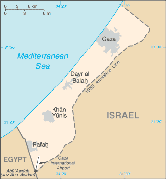
| Soat-bêng | A map of the Gaza Strip | |||
| Ji̍t-kî |
Taken from CIA World Factbook website on 28 August 2006. Please note that this is not the original CIA map; it has been edited to remove the text Israeli-occupied with current status subject to the Israeli-Palestinian Interim Agreement - permanent status to be determined through further negotiation (compare e.g. [1]). |
|||
| Chhut-chhù | CIA World Factbook | |||
| Chok-chiá | CIA | |||
| 授權允准 (Bô siŏh-huòi sāi ciā ùng-giông) |
Public domain, as is all content from the CIA factbook
|

檔案歷史
揤日期/時間,看彼時陣的檔案.
| 日期/ 時間 | 細張圖 | 寸尺 | 用者 | 註解 | |
|---|---|---|---|---|---|
| 現在 | 2021年5月20日 (拜4) 21:16 | | 328 × 352(8 KB) | Jul059 | Lossless file size reduction |
影像連結
以下的頁連到這个影像: