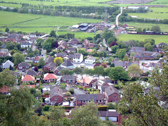
tóng-àn:Helsby Village - geograph.org.uk - 11574.jpg
Lohankhapedia (自由的百科全書) 欲共你講..。
跳至導覽
跳至搜尋
Helsby_Village_-_geograph.org.uk_-_11574.jpg (640 × 480 像素,檔案佔量: 438 KB,MIME類型: image/jpeg)
|
|
這是對Wikimedia Commons引來的一份檔案。伊佇hia ê kì-su̍t-ia̍h頂面的資訊顯示對下底. |
Khài-iàu
| Soat-bêngHelsby Village - geograph.org.uk - 11574.jpg |
English: Helsby Village. As seen from the very steep sandstone hill to the east. Taken from 492755 looking north west, the minor road bridge over the M56 can be seen towards the top of the picture with the radio/telephone mast close by. |
| Ji̍t-kî | |
| Chhut-chhù | From geograph.org.uk |
| Chok-chiá | Gary Rogers |
| Piau-sī miâ-sìnn (由许可协议要求) InfoField | Gary Rogers / Helsby Village / |
InfoField | Gary Rogers / Helsby Village |
| 拍攝地點 | 53° 16′ 26″ 北, 2° 45′ 48″ 西 | 位於此地的本圖片與其他圖片: OpenStreetMap |
|---|
| 目標地點 | 53° 16′ 30.8″ 北, 2° 46′ 05″ 西 | 位於此地的本圖片與其他圖片: OpenStreetMap |
|---|
Siū-khoân

|
此檔案採用創用CC 姓名標示-相同方式分享 2.0 通用版授權條款。
Piau-sī miâ-sìnn: Gary Rogers
- Lí ē-sái tsū-iû:
- hun-hióng – kho͘-pih, hoat-pò͘ kap thoân-pò͘ pún chok
- tiông-sin siu-kái – kái-pian pún chok-phín
- Àn i-hā ê tiâu-kiāⁿ
- Piau-sī miâ-sìnn – Lí ài siá-bîng tsìng-khak ê miâ-hō, ū siū-khuân tiâu-khuán ê liân-kiat, iáu-koh-ū lí tsuè siánn-mih ê kái-piàn. Lí ē-tàng tī jīm-hô ha̍p-lí ê hong-sik tsìn-hîng, m̄-kò buē-tàng ti̍t-tsiap kóng siū-khuân hōo lí ia̍h-sī lí sú-iōng.
- Kâng-khuán hong-sik hun-hióng – Lí nā kái-tōng, piàn-khoán, he̍k-chiá kun-kù pún chok chhòng-chō, lí kaⁿ-taⁿ ē-tàng ēng kap pún chok kâng-khoán he̍k-chiá saⁿ-chhiūⁿ ê hí-khó lâi hoat-pò͘ chò--chhut-lâi ê chok-phín.
說明
添加單行說明來描述出檔案所代表的內容
在此檔案描寫的項目
描繪內容 繁體中文
授權條款 繁體中文
檔案來源 Chinese (Taiwan) (已轉換拼寫)
20 5 2005
多媒體型式 繁體中文
image/jpeg
資料大小 繁體中文
448,362 Byte
高度 繁體中文
480 ōe-sò͘
寬度 繁體中文
640 ōe-sò͘
製作地點 中文 (已轉換拼寫)
檔案歷史
揤日期/時間,看彼時陣的檔案.
| 日期/ 時間 | 細張圖 | 寸尺 | 用者 | 註解 | |
|---|---|---|---|---|---|
| 現在 | 2013年2月1日 (拜5) 08:01 |  | 640 × 480(438 KB) | wikimediacommons>Citypeek | white balance |
影像連結
以下的頁連到這个影像:
