tóng-àn:Kansas City Kansas aerial view.jpg
跳至導覽
跳至搜尋


先看佔量: 800 × 534 像素. 其他的 kái-sek-tō͘: 320 × 214 像素 | 640 × 427 像素 | 1,024 × 683 像素 | 1,500 × 1,001 像素.
全解析度 (1,500 × 1,001 像素,檔案佔量: 579 KB,MIME類型: image/jpeg)
|
|
這是對Wikimedia Commons引來的一份檔案。伊佇hia ê kì-su̍t-ia̍h頂面的資訊顯示對下底. |
Khài-iàu
| Soat-bêng |
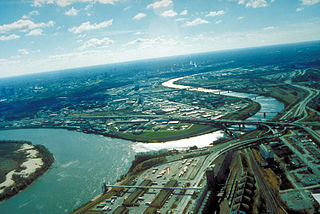
English: Aerial view of Kansas City, Kansas, looking southwest. The Kansas River (right-center) joins the Missouri River (left). A small piece of Kansas City, Missouri is visible on the left of the Missouri River. |
| 圖中地點 | City of Kansas City, State of Kansas, United States of America 39°6′54.64″N 94°36′36.34″W / 39.1151778°N 94.6100944°W |
| Ji̍t-kî | 攝於1999年4-goe̍h6日 |
| Chhut-chhù |
U.S. Army Corp of Engineers Digital Visual Library Image page Image description page Digital Visual Library home page |
| Chok-chiá | U.S. Army Corps of Engineers, photographer unknown |
Siū-khoân
This image or file is a work of a U.S. Army Corps of Engineers soldier or employee, taken or made as part of that person's official duties. As a work of the U.S. federal government, the image is in the public domain.
|
檔案歷史
揤日期/時間,看彼時陣的檔案.
| 日期/ 時間 | 細張圖 | 寸尺 | 用者 | 註解 | |
|---|---|---|---|---|---|
| 現在 | 2007年3月17日 (拜6) 09:48 | | 1,500 × 1,001(579 KB) | DanMS | {{Information | Description = Aerial view of Kansas City, Kansas, looking southwest. The Kansas River (right-center) joins the Missouri River (left). A small piece of Kansas City, Missouri is visible on the left of the Missouri River. | Source = U.S. |
影像連結
以下的頁連到這个影像: