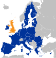
tóng-àn:Location map of the United Kingdom and the European Union.svg
Lohankhapedia (自由的百科全書) 欲共你講..。
跳至導覽
跳至搜尋

此 SVG 檔案的 PNG 預覽的大小:587 × 600 像素。 其他的 kái-sek-tō͘: 235 × 240 像素 | 470 × 480 像素 | 752 × 768 像素 | 1,002 × 1,024 像素 | 593 × 606 像素.
全解析度 (SVG ùng-giông, chék-cháung: 593 × 606 chuông-só, ùng-giông duâi-nâung:708 KB)
|
|
這是對Wikimedia Commons引來的一份檔案。伊佇hia ê kì-su̍t-ia̍h頂面的資訊顯示對下底. |
Khài-iàu
| Soat-bêngLocation map of the United Kingdom and the European Union.svg |
Deutsch: Lage des Vereinigten Königreichs in der Europäischen Union 2016.
English: Location of the United Kingdom and the European Union
Kingdom #003399 #c0c0c0 countries Other |
||||
| Ji̍t-kî | |||||
| Chhut-chhù |
本檔案衍生自: EU Single Market.svg: |
||||
| Chok-chiá | Furfur | ||||
| 授權允准 (Bô siŏh-huòi sāi ciā ùng-giông) |
|
||||
| SVG開發 InfoField | |||||
| Valide/Erzeugt mit InfoField |
說明
添加單行說明來描述出檔案所代表的內容
The UK (orange) and the European Union (blue)
Storbrittanien och EU
Localização do Reino Unido na União Europeia
Birleşik Krallık (turuncu) ve Avrupa Birliği (mavi)
Het VK (oranje) en de Europese Unie (blauw)
پادشاهی متحده (نارنجی) و اتحادیهٔ اروپا (آبی)
在此檔案描寫的項目
描繪內容 繁體中文
11 1 2016
多媒體型式 繁體中文
image/svg+xml
檔案歷史
揤日期/時間,看彼時陣的檔案.
| 日期/ 時間 | 細張圖 | 寸尺 | 用者 | 註解 | |
|---|---|---|---|---|---|
| 現在 | 2022年12月27日 (拜2) 18:10 |  | 593 × 606(708 KB) | Iktsokh | Correction of borders |
影像連結
以下的頁連到這个影像:
元資料
這个檔案有伊的資訊,可能是相機抑掃描機用的。
若改過這个檔案,資訊就無完全對著。
| 簡稱 | Countries of Europe |
|---|---|
| 影像標題 | A blank Map of Europe. Every country has an id which is its ISO-3166-1-ALPHA2 code in lower case.
Members of the EU have a class="eu", countries in europe (which I found turkey to be but russia not) have a class="europe".
Certain countries are further subdivided the United Kingdom has gb-gbn for Great Britain and gb-nir for Northern Ireland. Russia is divided into ru-kgd for the Kaliningrad Oblast and ru-main for the Main body of Russia. There is the additional grouping #xb for the "British Islands" (the UK with its Crown Dependencies - Jersey, Guernsey and the Isle of Man) and the Kingdom of Denmark (Denmark, Faroe Islands, Greenland)

Contributors.
Original Image: (-{R|http://commons.wikimedia.org/wiki/Image:Europe_countries.svg}-) Júlio Reis (-{R|http://commons.wikimedia.org/wiki/User:Tintazul}-).
Recolouring and tagging with country codes: Marian "maix" Sigler (-{R|http://commons.wikimedia.org/wiki/User:Maix}-)
Improved geographical features: -{R|http://commons.wikimedia.org/wiki/User:W!B}-:
Updated to reflect dissolution of Serbia & Montenegro: -{R|http://commons.wikimedia.org/wiki/User:Zirland}-
Updated to include British Crown Dependencies as seperate entities and regroup them as "British Islands", with some simplifications to the XML and CSS: James Hardy (-{R|http://commons.wikimedia.org/wiki/User:MrWeeble}-)
Validated (-{R|http://commons.wikimedia.org/wiki/User:CarolSpears}-)
Changed the country code of Serbia to RS per -{R|http://en.wikipedia.org/wiki/Serbian_country_codes}- and the file -{R|http://www.iso.org/iso/iso3166_en_code_lists.txt}- (-{R|http://commons.wikimedia.org/wiki/User:TimothyBourke}-)
Uploaded on behalf of User:Checkit, direct complaints to him plox: 'Moved countries out of the "outlines" group, removed "outlines" style class, remove separate style information for Russia' (-{R|http://commons.wikimedia.org/wiki/User:Collard}-)
Updated various coastlines and boarders and added various islands not previously shown (details follow). Added Kosovo, Northern Cyprus, Crimea, Abkhazia, South Ossetia, Transnistria and Nagorno-Karabakh as disputed territories. Moved major lakes to their own object and added more. List of updated boarders/coastlines: British Isles (+ added Isle of Wight, Skye, various smaller islands), the Netherlands, Germany, Austria, Hungary, Czech Republic, Denmark, Sweden, Finland, Poland, Kaliningrad Oblast of the Russian Federation (and minor tweaks to Lithuania), Estonia, Ukraine, Moldova (minor), Romania, Bulgaria, Turkey, Greece, F.Y.R. Macedonia, Serbia, Bosnia and Herzegovina, Montenegro, Albania, Croatia, Italy (mainland and Sicily), Malta (-{R|http://commons.wikimedia.org/wiki/User:Alphathon}-).
Added Bornholm (-{R|http://commons.wikimedia.org/wiki/User:Heb}-)
Released under CreativeCommons Attribution ShareAlike (-{R|http://creativecommons.org/licenses/by-sa/2.5/}-). |
| 寬度 | 593 |
| 高度 | 606 |