tóng-àn:Map of the Western Cape with Cape Town highlighted (2016).svg
跳至導覽
跳至搜尋


此 SVG 檔案的 PNG 預覽的大小:753 × 600 像素。 其他的 kái-sek-tō͘: 302 × 240 像素 | 603 × 480 像素 | 965 × 768 像素 | 1,280 × 1,019 像素 | 849 × 676 像素.
全解析度 (SVG ùng-giông, chék-cháung: 849 × 676 chuông-só, ùng-giông duâi-nâung:478 KB)
|
|
這是對Wikimedia Commons引來的一份檔案。伊佇hia ê kì-su̍t-ia̍h頂面的資訊顯示對下底. |
.svg)
Khài-iàu
| Soat-bêng |
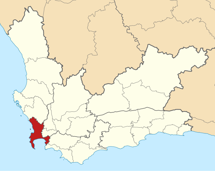
English: Map of municipal boundaries in the Western Cape, as they are after the municipal elections of 3 August 2016, with the City of Cape Town Metropolitan Municipality highlighted in red. Based on File:Map of the Western Cape with municipalities blank (2016).svg. |
| Ji̍t-kî | |
| Chhut-chhù | Ka-tī chò--ê |
| Chok-chiá | Htonl |
.svg)
Siū-khoân
我,本作品的著作權持有者,決定用以下授權條款發佈本作品:

|
已授權您依據自由軟體基金會發行的無固定段落、封面文字和封底文字GNU自由文件授權條款1.2版或任意後續版本,對本檔進行複製、傳播和/或修改。該協議的副本列在GNU自由文件授權條款中。 |
This file is licensed under the Creative Commons Attribution-Share Alike 4.0 International, 3.0 Unported, 2.5 Generic, 2.0 Generic and 1.0 Generic license.
- 你會使自由:
- 分享 – kho͘-pih, hoat-pò͘ kap thoân-pò͘ pún chok
- 重新修改 – kái-pian pún chok-phín
- Àn i-hā ê tiâu-kiāⁿ
- 標示名姓 – 您必須指名出正確的製作者,和提供授權條款的連結,以及表示是否有對內容上做出變更。您可以用任何合理的方式來行動,但不得以任何方式表明授權條款是對您許可或是由您所使用。
- 仝款方式方享 – Lí nā kái-tōng, piàn-khoán, he̍k-chiá kun-kù pún chok chhòng-chō, lí kaⁿ-taⁿ ē-tàng ēng kap pún chok kâng-khoán he̍k-chiá saⁿ-chhiūⁿ ê hí-khó lâi hoat-pò͘ chò--chhut-lâi ê chok-phín.
Nṳ̄ buóh dĭk sié-nó̤h sêu-guòng dèu-kuāng dŭ kō̤-ī gēng.
檔案歷史
揤日期/時間,看彼時陣的檔案.
| 日期/ 時間 | 細張圖 | 寸尺 | 用者 | 註解 | |
|---|---|---|---|---|---|
| 現在 | 2016年9月11日 (禮拜) 23:44 | | 849 × 676(478 KB) | Htonl | == {{int:filedesc}} == {{Information |Description ={{en|1=Map of municipal boundaries in the w:Western Cape, as they are after the municipal elections of 3 August 2016, with the [[w:City of Cape Town... |
影像連結
以下的頁連到這个影像:
.svg)
.svg)
.svg&action=edit&redlink=1)
.svg&variant=nan)
.svg&variant=nan-hant)
.svg&variant=nan-hans-ruby)
.svg&variant=nan-hans)
.svg&action=edit)
.svg)
.svg&printable=yes)
.svg&action=info)
.svg&mobileaction=toggle_view_mobile)