這是一份對Wikimedia Commons引來的檔案

tóng-àn:MinasGerais Municip Acucena.svg

Lohankhapedia (自由的百科全書) 欲共你講..。
跳至導覽 跳至搜尋

全解析度(SVG ùng-giông, chék-cháung: 2,147 × 1,723 chuông-só, ùng-giông duâi-nâung:2.9 MB)

  Standardization of derivative maps

Feel free to create derivations of this work, but if you want to illustrate a Wikipedia article with derivative works of this or similar maps of Brazil, please strictly follow the visual standard, nomenclature and classification already in use. All maps of Brazilian subdivisions are being adaptated or created in this way. We do not want to inhibit creativity but the pattern adopted here was presented and accepted by the Lusophone community and should be followed whenever possible.

Khài-iàu

Soat-bêng
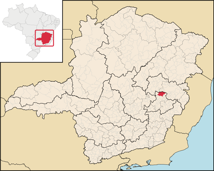
English: Location map of the municipality of Açucena in Minas Gerais state, Brazil.
Português: Localização do município de Açucena no estado de Minas Gerais, Brasil.
Ji̍t-kî
Chhut-chhù File:Brazil Minas Gerais location map.svg (derivate for File:MinasGerais MesoMicroMunicip.svg)
Chok-chiá

Siū-khoân

w:zh:創用CC
Piau-sī miâ-sìnn
此檔案採用創用CC 姓名標示 2.5 通用版授權條款。
Lí ē-sái tsū-iû:
  • hun-hióng – kho͘-pih, hoat-pò͘ kap thoân-pò͘ pún chok
  • tiông-sin siu-kái – kái-pian pún chok-phín
Àn i-hā ê tiâu-kiāⁿ
  • Piau-sī miâ-sìnn – Lí ài siá-bîng tsìng-khak ê miâ-hō, ū siū-khuân tiâu-khuán ê liân-kiat, iáu-koh-ū lí tsuè siánn-mih ê kái-piàn. Lí ē-tàng tī jīm-hô ha̍p-lí ê hong-sik tsìn-hîng, m̄-kò buē-tàng ti̍t-tsiap kóng siū-khuân hōo lí ia̍h-sī lí sú-iōng.

說明

添加單行說明來描述出檔案所代表的內容

在此檔案描寫的項目

描繪內容 繁體中文

著作權狀態 繁體中文

有著作權 繁體中文

多媒體型式 繁體中文

image/svg+xml

檔案歷史

揤日期/時間,看彼時陣的檔案.

日期/ 時間細張圖寸尺用者註解
現在2020年8月15日 (拜6) 12:332020年8月15日 (拜6) 12:33版本的細圖2,147 × 1,723(2.9 MB)wikimediacommons>Apollo BRAtualização das mesorregiões e microrregiões de Minas Gerais para regiões geográficas intermediárias e regiões geográficas imediatas, respectivamente, segundo nova classificação do IBGE de 2017. Fonte: IBGE 2017 <https://www.ibge.gov.br/apps/regioes_geograficas/> Base Cartográfica: IBGE 2019 <https://www.ibge.gov.br/geociencias/organizacao-do-territorio/15774-malhas.html?=&t=downloads> Elaboração: Trabalho próprio, com o software QGIS. Formatação das camadas: MINAS GERAIS: borda= 0,66 mm...

以下的頁連到這个影像:

元資料