tóng-àn:Moon Farside LRO.jpg

全解析度 (18,000 × 18,000 像素,檔案佔量: 85.34 MB,MIME類型: image/jpeg)
|
|
這是對Wikimedia Commons引來的一份檔案。伊佇hia ê kì-su̍t-ia̍h頂面的資訊顯示對下底. |
| 警告 | 部分瀏覽器在瀏覽此圖片的完整大小時可能會遇到困難:該圖片中有數量巨大的像素點,可能無法完全載入或者導致您的瀏覽器停止回應。 | 交互式大图查看器 |
|---|
Lower-resolution versions: 6000px, 3000px, and 1000px
Khài-iàu
| Soat-bêngMoon Farside LRO.jpg |
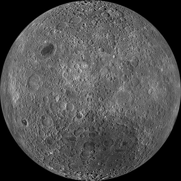
English: Far side of the moon, by NASA's Lunar Reconnaissance Orbiter. Orthographic projection centred at 180° longitude, 0° latitude.
Because the moon is tidally locked (meaning the same side always faces Earth), it was not until 1959 that the farside was first imaged by the Soviet Luna 3 spacecraft (hence the Russian names for prominent farside features, such as Mare Moscoviense). And what a surprise – unlike the widespread maria on the nearside, basaltic volcanism was restricted to a relatively few, smaller regions on the farside, and the battered highlands crust dominated. A different world from what we saw from Earth. Of course, the cause of the farside/nearside asymmetry is an interesting scientific question. Past studies have shown that the crust on the farside is thicker, likely making it more difficult for magmas to erupt on the surface, limiting the amount of farside mare basalts. Why is the farside crust thicker? That is still up for debate, and in fact several presentations at this week's Lunar and Planetary Science Conference attempt to answer this question. The Clementine mission obtained beautiful mosaics with the sun high in the sky (low phase angles), but did not have the opportunity to observe the farside at sun angles favorable for seeing surface topography. This WAC mosaic provides the most complete look at the morphology of the farside to date and will provide a valuable resource for the scientific community. And it's simply a spectacular sight! The Lunar Reconnaissance Orbiter Camera (LROC) Wide Angle Camera (WAC) is a push-frame camera that captures seven color bands (321, 360, 415, 566, 604, 643, and 689 nm) with a 57 km swath (105 km swath in monochrome mode) from a 50 km orbit. One of the primary objectives of LROC is to provide a global 100 m/px monochrome (643 nm) base map with incidence angles between 55° and 70° at the equator, lighting that is favorable for morphological interpretations. Each month, the WAC provides nearly complete coverage of the Moon under unique lighting. As an added bonus, the orbit-to-orbit image overlap provides stereo coverage. Reducing all these stereo images into a global topographic map is a big job, which is being led by LROC Team Members from the German Aerospace Center (Deutsches Zentrum für Luft- und Raumfahrt; DLR). Several preliminary WAC topographic products have appeared in LROC featured images over the past year (Orientale basin, Sinus Iridum). The WAC topographic dataset will be completed and released later this year. The global mosaic released today is comprised of over 15,000 WAC images acquired between November 2009 and February 2011. The non-polar images were map-projected onto the GLD100 shape model (WAC derived 100 m/px DTM), while polar images were map-projected on the LOLA shape model. In addition, the LOLA-derived crossover-corrected ephemeris and an improved camera pointing provide accurate positioning (better than 100 m) of each WAC image. |
| Ji̍t-kî |
在2009年11-goe̍h到2011年2-goe̍h之間 date QS:P,+2050-00-00T00:00:00Z/7,P1319,+2009-11-00T00:00:00Z/10,P1326,+2011-02-00T00:00:00Z/10 |
| Chhut-chhù | http://wms.lroc.asu.edu/lroc_browse/view/WAC_GL180 (see also http://photojournal.jpl.nasa.gov/catalog/PIA14021) |
| Chok-chiá | NASA/GSFC/Arizona State University |
| 其他版本 | Lower-resolution versions: 6000px, 3000px, and 1000px |
| 此標籤不表示文件的著作權狀態。任何文件在附有此標籤的同時還需要一個有效的著作權標籤。請參閱許可協議說明頁面以了解更多資訊。 其他語言:
العربية ∙ беларуская (тарашкевіца) ∙ български ∙ Bahaso Jambi ∙ català ∙ čeština ∙ dansk ∙ Deutsch ∙ English ∙ español ∙ فارسی ∙ français ∙ galego ∙ magyar ∙ հայերեն ∙ Bahasa Indonesia ∙ italiano ∙ 日本語 ∙ македонски ∙ മലയാളം ∙ Nederlands ∙ polski ∙ português ∙ русский ∙ sicilianu ∙ slovenščina ∙ Türkçe ∙ українська ∙ 简体中文 ∙ 繁體中文 ∙ +/− |
Siū-khoân
| Public domainPublic domainfalsefalse |
| 本作品由NASA創作,屬於公有領域。根據NASA的版權政策:“NASA的創作除非另有聲明否則不受版權保護。”(參見:Template:PD-USGov/zh,NASA版權政策或JPL圖像使用政策) |  | |
 |
警告:
|
| Annotations InfoField | This image is annotated: View the annotations at Commons |
說明
在此檔案描寫的項目
描繪內容 繁體中文
檔案歷史
揤日期/時間,看彼時陣的檔案.
| 日期/ 時間 | 細張圖 | 寸尺 | 用者 | 註解 | |
|---|---|---|---|---|---|
| 現在 | 2014年3月19日 (拜3) 23:47 |  | 18,000 × 18,000(85.34 MB) | wikimediacommons>Huntster | High resolution mosaic. |
影像連結
以下的頁連到這个影像: