tóng-àn:Mountain Fork Bridge.jpg
跳至導覽
跳至搜尋

先看佔量: 471 × 599 像素. 其他的 kái-sek-tō͘: 189 × 240 像素 | 377 × 480 像素 | 472 × 600 像素 | 604 × 768 像素 | 805 × 1,024 像素 | 3,691 × 4,693 像素.
全解析度 (3,691 × 4,693 像素,檔案佔量: 1.61 MB,MIME類型: image/jpeg)
|
|
這是對Wikimedia Commons引來的一份檔案。伊佇hia ê kì-su̍t-ia̍h頂面的資訊顯示對下底. |
| 拍攝地點 | | 位於此地的本圖片與其他圖片: OpenStreetMap |
|---|
| Soat-bêng |
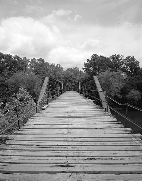
English: Looking west on the Mountain Fork Bridge, which carries County Road 38 over Mountain Fork Creek near Mena in Saline County, Arkansas, United States. Built in 1926, this Pratt pony truss bridge is listed on the National Register of Historic Places. |
||||
| Ji̍t-kî | |||||
| Chhut-chhù | Library of Congress, Prints and Photograph Division HAER: ARK,57-CAPI.V,1-3 | ||||
| Chok-chiá | Jeff Holder | ||||
| 授權允准 (Bô siŏh-huòi sāi ciā ùng-giông) |
|

|
|
檔案歷史
揤日期/時間,看彼時陣的檔案.
| 日期/ 時間 | 細張圖 | 寸尺 | 用者 | 註解 | |
|---|---|---|---|---|---|
| 現在 | 2009年12月13日 (禮拜) 10:03 | | 3,691 × 4,693(1.61 MB) | Nyttend | {{Location|34|31|41|N|94|24|0|W}} {{Information |Description={{en|Looking west on the {{w|Mountain Fork Bridge}}, which carries County Road 38 over Mountain Fork Creek near {{w|Mena, Arkansas|Mena}} in {{w|Saline County, Arkansas|Saline County}}, {{w|Arka |
影像連結
以下的頁連到這个影像: