tóng-àn:Obcine Slovenija 2006.svg
跳至導覽
跳至搜尋


此 SVG 檔案的 PNG 預覽的大小:800 × 522 像素。 其他的 kái-sek-tō͘: 320 × 209 像素 | 640 × 418 像素 | 1,024 × 668 像素 | 1,280 × 835 像素 | 2,613 × 1,705 像素.
全解析度 (SVG ùng-giông, chék-cháung: 2,613 × 1,705 chuông-só, ùng-giông duâi-nâung:2.31 MB)
|
|
這是對Wikimedia Commons引來的一份檔案。伊佇hia ê kì-su̍t-ia̍h頂面的資訊顯示對下底. |
Khài-iàu
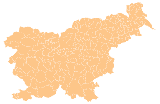
| Soat-bêng | Map of the municipalities (občine) of the Republic of Slovenia, as since May 2006 (210 units). |
| Ji̍t-kî | |
| Chhut-chhù | Source of the public data is GURS (Geodetska uprava Republike Slovenije or Surveying and Mapping Authority of the Republic of Slovenia). Converted from Shapefile to SVG with shp2svg and prepared for Wikipedia by romanm (talk). |
| Chok-chiá | See above. |
| 授權允准 (Bô siŏh-huòi sāi ciā ùng-giông) |
See Pogoji uporabe (in Slovene) and Terms and conditions (English). According to price list, which states cost 0€ for using free-of-charge published data on municipalities even for commercial purposes(!), I consider the data to be in public domain. I also hereby grant my work on this file to be in public domain. |
| 其他版本 |
|

Siū-khoân
| 我,此作品的版權所有人,釋出此作品至公共領域。此授權條款在全世界均適用。 這可能在某些國家不合法,如果是的話: 我授予任何人有權利使用此作品於任何用途,除受法律約束外,不受任何限制。 |
檔案歷史
揤日期/時間,看彼時陣的檔案.
| 日期/ 時間 | 細張圖 | 寸尺 | 用者 | 註解 | |
|---|---|---|---|---|---|
| 現在 | 2012年4月14日 (拜6) 00:19 | | 2,613 × 1,705(2.31 MB) | Martin Kraft | size and display problem fixed reduced number of points |
影像連結
無半頁連到這張影像.