tóng-àn:Pyrenees Mountains view from satellite.jpg
跳至導覽
跳至搜尋

先看佔量: 780 × 600 像素. 其他的 kái-sek-tō͘: 312 × 240 像素 | 624 × 480 像素 | 999 × 768 像素 | 1,280 × 985 像素 | 2,600 × 2,000 像素.
全解析度 (2,600 × 2,000 像素,檔案佔量: 877 KB,MIME類型: image/jpeg)
|
|
這是對Wikimedia Commons引來的一份檔案。伊佇hia ê kì-su̍t-ia̍h頂面的資訊顯示對下底. |
Khài-iàu
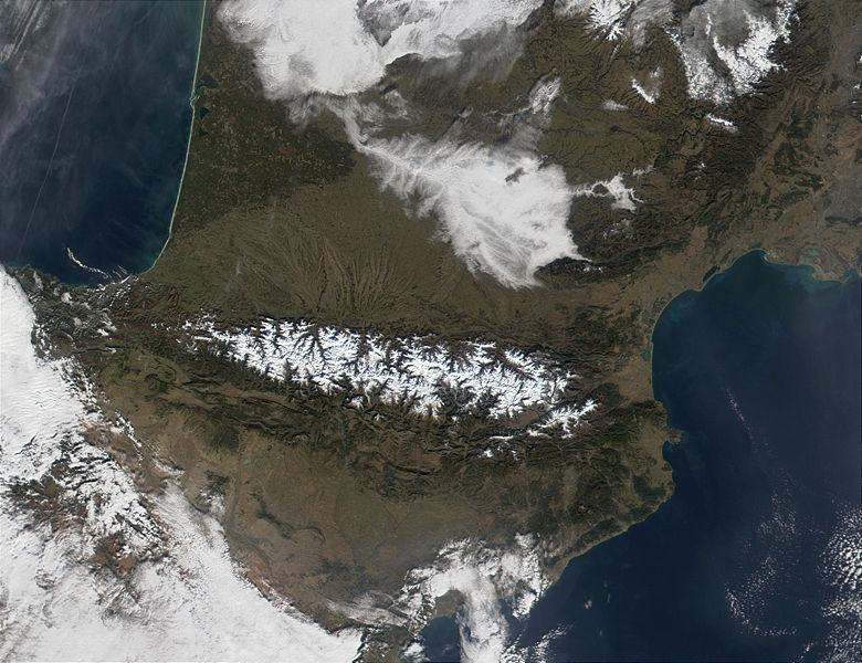
| Soat-bêng | The Pyrenees Mountains (center) act as a natural border between France to the north and Spain to the south. In this MODIS image from January 18, 2002, they are covered in snow (bright red in the false-color image.) At upper left, contrails are visible over the Bay of Biscay, which, along the French shores, sport miles and miles of white sandy beaches. |
| Ji̍t-kî | |
| Chhut-chhù | http://visibleearth.nasa.gov/view_rec.php?id=2690 |
| Chok-chiá | Jacques Descloitres, MODIS Land Rapid Response Team, NASA/GSFC |
Siū-khoân
| 本作品由NASA創作,屬於公有領域。根據NASA的版權政策:“NASA的創作除非另有聲明否則不受版權保護。”(參見:Template:PD-USGov/zh,NASA版權政策或JPL圖像使用政策) | ||
 |
警告:
|
檔案歷史
揤日期/時間,看彼時陣的檔案.
| 日期/ 時間 | 細張圖 | 寸尺 | 用者 | 註解 | |
|---|---|---|---|---|---|
| 現在 | 2004年12月4日 (拜6) 04:30 | | 2,600 × 2,000(877 KB) | Alfio | pyrenees mountains seen from satellite |
影像連結
以下的頁連到這个影像: