tóng-àn:Rajendra map new.svg
跳至導覽
跳至搜尋


此 SVG 檔案的 PNG 預覽的大小:466 × 333 像素。 其他的 kái-sek-tō͘: 320 × 229 像素 | 640 × 457 像素 | 800 × 572 像素 | 1,024 × 732 像素 | 1,280 × 915 像素.
全解析度 (SVG ùng-giông, chék-cháung: 466 × 333 chuông-só, ùng-giông duâi-nâung:220 KB)
|
|
這是對Wikimedia Commons引來的一份檔案。伊佇hia ê kì-su̍t-ia̍h頂面的資訊顯示對下底. |
Khài-iàu
| Soat-bêng |
per http://cw.routledge.com/textbooks/9780415485432/15.asp "THE CŌḶAS" by K. A. Nilakanta Sastri and other histories of South Asia consulted.
The file has several changes from the original. The map is corrected to show are of influence and direct control in Sri Lanka. Correction was based on the work of Spencer, G. (1976). The Politics of Plunder: The Cholas in Eleventh-Century Ceylon. The Journal of Asian Studies, 35(3), 405-419. doi:10.2307/2053272. The correction about the Chola influence in Malay areas is based on https://archive.org/details/earlykingdomsofi0000muno/page/118/mode/2up The influence added the area of Lamuri based on Tanjore inscription. Andaman is deleted leaving only Nicobar (information on Tanjore inscription). |
| Ji̍t-kî | (UTC) |
| Chhut-chhù | |
| Chok-chiá |
|
| 這是一張修飾過的圖片,即本圖片是用軟體修改過後的版本,修改的方式或內容有:Redrew png as svg。原版圖片來源:Rajendra map new.png。修改者:Gregors。
|
我,本作品的著作權持有者,決定用以下授權條款發佈本作品:
| 此檔案採用創用CC 姓名標示-相同方式分享 3.0 未在地化版本授權條款。 受免責聲明的約束。 | ||
| ||
| 已新增授權條款標題至此檔案,作為GFDL授權更新的一部份。 |

|
已授權您依據自由軟體基金會發行的無固定段落、封面文字和封底文字GNU自由文件授權條款1.2版或任意後續版本,對本檔進行複製、傳播和/或修改。該協議的副本列在GNU自由文件授權條款中。 |
Nṳ̄ buóh dĭk sié-nó̤h sêu-guòng dèu-kuāng dŭ kō̤-ī gēng.
原始上傳日誌
This image is a derivative work of the following images:
- File:Rajendra_map_new.png licensed with Cc-by-sa-3.0-migrated-with-disclaimers, GFDL-en, GFDL-user-en-with-disclaimers
- 2011-03-21T12:16:23Z Gregors 600x429 (102117 Bytes) Bitmap of svg that i will soon upload. ~~~~
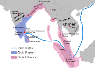
- 2009-06-07T09:04:06Z Maukie 629x442 (215021 Bytes) {{Information |Description={{en|Map showing the extent of the [[:en:Chola empire|]] during [[:en:Rajendra Chola I|]] (c. 1030 CE)}} |Source=Transferred from [http://en.wikipedia.org en.wikipedia]; transfer was stated to be ma
Uploaded with derivativeFX
檔案歷史
揤日期/時間,看彼時陣的檔案.
| 日期/ 時間 | 細張圖 | 寸尺 | 用者 | 註解 | |
|---|---|---|---|---|---|
| 現在 | 2024年5月24日 (拜5) 11:54 | | 466 × 333(220 KB) | SKAG123 | Reverted to version as of 15:53, 12 May 2024 (UTC) Vandalism |
影像連結
以下的頁連到這个影像: