tóng-àn:Rugby UK locator map.svg
跳至導覽
跳至搜尋


此 SVG 檔案的 PNG 預覽的大小:493 × 599 像素。 其他的 kái-sek-tō͘: 197 × 240 像素 | 395 × 480 像素 | 494 × 600 像素 | 632 × 768 像素 | 843 × 1,024 像素 | 1,042 × 1,266 像素.
全解析度 (SVG ùng-giông, chék-cháung: 1,042 × 1,266 chuông-só, ùng-giông duâi-nâung:911 KB)
|
|
這是對Wikimedia Commons引來的一份檔案。伊佇hia ê kì-su̍t-ia̍h頂面的資訊顯示對下底. |
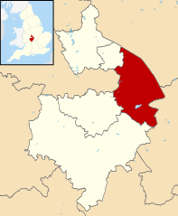
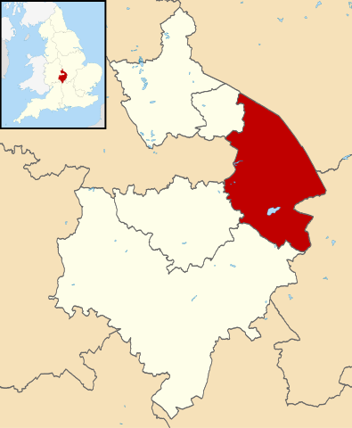
| Soat-bêng | Map of Warwickshire, with Rugby highlighted. |
| Ji̍t-kî | (UTC) |
| Chhut-chhù | |
| Chok-chiá |
|
.svg)
我,本作品的著作權持有者,決定用以下授權條款發佈本作品:
此檔案採用創用CC 姓名標示-相同方式分享 3.0 未在地化版本授權條款。
- 你會使自由:
- 分享 – kho͘-pih, hoat-pò͘ kap thoân-pò͘ pún chok
- 重新修改 – kái-pian pún chok-phín
- Àn i-hā ê tiâu-kiāⁿ
- 標示名姓 – 您必須指名出正確的製作者,和提供授權條款的連結,以及表示是否有對內容上做出變更。您可以用任何合理的方式來行動,但不得以任何方式表明授權條款是對您許可或是由您所使用。
- 仝款方式方享 – Lí nā kái-tōng, piàn-khoán, he̍k-chiá kun-kù pún chok chhòng-chō, lí kaⁿ-taⁿ ē-tàng ēng kap pún chok kâng-khoán he̍k-chiá saⁿ-chhiūⁿ ê hí-khó lâi hoat-pò͘ chò--chhut-lâi ê chok-phín.
原始上傳日誌
This image is a derivative work of the following images:
- File:Warwickshire UK district map (blank).svg licensed with Cc-by-sa-3.0
- 2010-08-22T08:21:14Z Nilfanion 1042x1266 (931105 Bytes) +inset, water colour tweak
- 2010-07-16T23:57:57Z Nilfanion 1042x1266 (557360 Bytes) {{Information |Description=Map of [[w:Warwickshire|Warwickshire]], UK with districts shown. Equirectangular map projection on WGS 84 datum, with N/S stretched 160% Geographic limits: *West: 2.10W *East: 1.10W *North: 52.70N
檔案歷史
揤日期/時間,看彼時陣的檔案.
| 日期/ 時間 | 細張圖 | 寸尺 | 用者 | 註解 | |
|---|---|---|---|---|---|
| 現在 | 2011年8月13日 (拜6) 17:22 | | 1,042 × 1,266(911 KB) | Renly~commonswiki | {{Information |Description=Map of Warwickshire, with Rugby highlighted. |Source=*Warwickshire UK district map (blank).svg |Date=2011-08-13 09:22 (UTC) |Author=*[[:File:Warwickshire UK district map (blank) |
.svg)
影像連結
以下的頁連到這个影像: