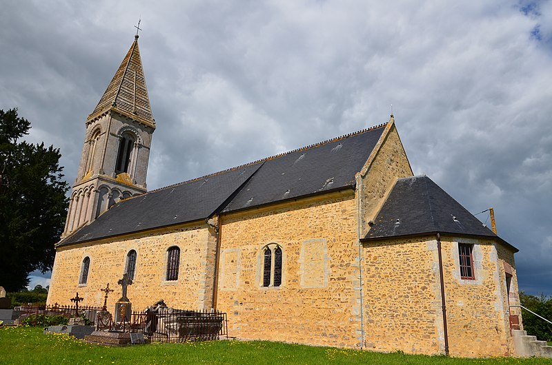
tóng-àn:Saint-Marcouf (Calvados) - Eglise Saint-Marcouf (2).JPG
Lohankhapedia (自由的百科全書) 欲共你講..。
跳至導覽
跳至搜尋

先看佔量: 800 × 530 像素. 其他的 kái-sek-tō͘: 320 × 212 像素 | 640 × 424 像素 | 1,024 × 678 像素 | 1,280 × 848 像素 | 2,560 × 1,696 像素 | 4,928 × 3,264 像素.
全解析度 (4,928 × 3,264 像素,檔案佔量: 6.36 MB,MIME類型: image/jpeg)
|
|
這是對Wikimedia Commons引來的一份檔案。伊佇hia ê kì-su̍t-ia̍h頂面的資訊顯示對下底. |
Khài-iàu
| Soat-bêngSaint-Marcouf (Calvados) - Eglise Saint-Marcouf (2).JPG |
Français : Église Saint-Marcouf de Saint-Marcouf.
|
||
| Ji̍t-kî | |||
| Chhut-chhù | Ka-tī chò--ê | ||
| Chok-chiá | S. Plaine | ||
| Siū-khuân ún-tsún (Koh iōng tsit-ê tóng-àn) |
|
||
| 拍攝地點 | 49° 15′ 05.37″ 北, 0° 59′ 26.91″ 西 | 位於此地的本圖片與其他圖片: OpenStreetMap |
|---|
Siū-khoân
我,本作品的著作權持有者,決定用以下授權條款發佈本作品:
此檔案採用創用CC 姓名標示-相同方式分享 4.0 國際授權條款。
- Lí ē-sái tsū-iû:
- hun-hióng – kho͘-pih, hoat-pò͘ kap thoân-pò͘ pún chok
- tiông-sin siu-kái – kái-pian pún chok-phín
- Àn i-hā ê tiâu-kiāⁿ
- Piau-sī miâ-sìnn – Lí ài siá-bîng tsìng-khak ê miâ-hō, ū siū-khuân tiâu-khuán ê liân-kiat, iáu-koh-ū lí tsuè siánn-mih ê kái-piàn. Lí ē-tàng tī jīm-hô ha̍p-lí ê hong-sik tsìn-hîng, m̄-kò buē-tàng ti̍t-tsiap kóng siū-khuân hōo lí ia̍h-sī lí sú-iōng.
- Kâng-khuán hong-sik hun-hióng – Lí nā kái-tōng, piàn-khoán, he̍k-chiá kun-kù pún chok chhòng-chō, lí kaⁿ-taⁿ ē-tàng ēng kap pún chok kâng-khoán he̍k-chiá saⁿ-chhiūⁿ ê hí-khó lâi hoat-pò͘ chò--chhut-lâi ê chok-phín.
說明
添加單行說明來描述出檔案所代表的內容
在此檔案描寫的項目
描繪內容 繁體中文
授權條款 繁體中文
創用CC姓名標示-相同方式分享4.0國際 繁體中文
23 8 2014
視角坐標 繁體中文
49°15'5.375"N, 0°59'26.909"W
製作地點 中文 (已轉換拼寫)
曝光時間 繁體中文
0.0025 bió
焦距比數 繁體中文
11
焦距 繁體中文
18 hò̤-mī
ISO速度 繁體中文
200
多媒體型式 繁體中文
image/jpeg
相片 繁體中文
檔案歷史
揤日期/時間,看彼時陣的檔案.
| 日期/ 時間 | 細張圖 | 寸尺 | 用者 | 註解 | |
|---|---|---|---|---|---|
| 現在 | 2014年8月23日 (拜6) 16:33 |  | 4,928 × 3,264(6.36 MB) | wikimediacommons>Buff | User created page with UploadWizard |
影像連結
以下的頁連到這个影像:
元資料
這个檔案有伊的資訊,可能是相機抑掃描機用的。
若改過這个檔案,資訊就無完全對著。
| 相機製造商 | NIKON CORPORATION |
|---|---|
| 相機型號 | NIKON D5100 |
| 方位 | 標準 |
| 水平解像度 | 300 dpi |
| 垂直解像度 | 300 dpi |
| 使用的軟體 | Ver.1.01 |
| 檔案改變的日子佮時間 | 2014年8月23日 (拜6) 13:10 |
| 亮度與彩度位置 | 同時取樣 |
| 曝光時間 | 1/400 秒 (0.0025) |
| 光圈值 | f/11 |
| 曝光模式 | 未定義 |
| ISO 速率 | 200 |
| Exif 版本 | 2.3 |
| 資料產生的日期時間 | 2014年8月23日 (拜6) 13:10 |
| 數位化的日期時間 | 2014年8月23日 (拜6) 13:10 |
| 每像素內含 |
|
| 影像壓縮模式 | 4 |
| APEX 曝光補償 | 0 |
| 最大陸地光圈 | 3.6 APEX(f/3.48) |
| 測光模式 | 模式 |
| 光源 | 不明 |
| 閃光燈 | 閃光燈未開啟, 強制閃光燈關閉 |
| 焦距 | 18毫米 |
| 時間數據亞秒數 | 90 |
| 文件建立時間數據亞秒數 | 90 |
| 文件數位化時間數據亞秒數 | 90 |
| 支援的 Flashpix 版本 | 1 |
| 色彩空間 | sRGB |
| 感光模式 | 單晶片彩色區域感測器 |
| 檔案來源 | 數位相機 |
| 場景類型 | 直接照像圖片 |
| 自訂影像處理 | 一般程序 |
| 曝光模式 | 自動曝光 |
| 白平衡 | 自動白平衡 |
| 數位變焦比率 | 1 |
| 35 毫米膠片焦距 | 27毫米 |
| 場景拍攝類型 | 風景 |
| 場景控制 | 無 |
| 對比度 | 標準 |
| 飽和度 | 標準 |
| 銳利度 | 標準 |
| 主體距離範圍 | 不明 |
| GPS 標籤版本 | 2.3.0.0 |
