tóng-àn:Santorini Museum Prehistoric Thera Linear A.jpg

|
|
這是對Wikimedia Commons引來的一份檔案。伊佇hia ê kì-su̍t-ia̍h頂面的資訊顯示對下底. |
Khài-iàu
| Soat-bêng |
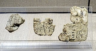
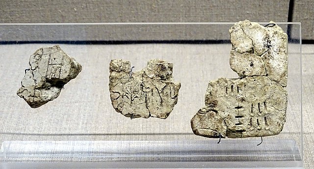
Nederlands: Kleitabletten geschreven in Lineair A, gevonden in Akrotiri in het Museum van Prehistorsch Thera (inv 8366,8367, 8368), Santorini, Griekenland. Laat-cycladische I periode (17de eeuw v.C.).
English: Clay tablets with Linear A script, found at Akrotiri, in the Museum of Prehistoric Thera (inv 8366,8367, 8368), Santonrini, Greece. Mature Late Cycladic I period (17th century BCE). |
| Ji̍t-kî | |
| Chhut-chhù | Ka-tī chò--ê |
| Chok-chiá |
Ad Meskens You are free to use this picture for any purpose as long as you credit its author, Ad Meskens. Example: © Ad Meskens / Wikimedia Commons
This file has been released under a license which is incompatible with Facebook's licensing terms. It is not permitted to upload this file to Facebook.
|

| 拍攝地點 | | 位於此地的本圖片與其他圖片: OpenStreetMap |
|---|
Siū-khoân
- 你會使自由:
- 分享 – kho͘-pih, hoat-pò͘ kap thoân-pò͘ pún chok
- 重新修改 – kái-pian pún chok-phín
- Àn i-hā ê tiâu-kiāⁿ
- 標示名姓 – 您必須指名出正確的製作者,和提供授權條款的連結,以及表示是否有對內容上做出變更。您可以用任何合理的方式來行動,但不得以任何方式表明授權條款是對您許可或是由您所使用。
- 仝款方式方享 – Lí nā kái-tōng, piàn-khoán, he̍k-chiá kun-kù pún chok chhòng-chō, lí kaⁿ-taⁿ ē-tàng ēng kap pún chok kâng-khoán he̍k-chiá saⁿ-chhiūⁿ ê hí-khó lâi hoat-pò͘ chò--chhut-lâi ê chok-phín.
檔案歷史
揤日期/時間,看彼時陣的檔案.
| 日期/ 時間 | 細張圖 | 寸尺 | 用者 | 註解 | |
|---|---|---|---|---|---|
| 現在 | 2019年12月28日 (拜6) 15:05 | | 4,879 × 2,623(3.97 MB) | Ad Meskens | User created page with UploadWizard |
影像連結
以下的頁連到這个影像: