tóng-àn:Seljuk Empire locator map.svg
Lohankhapedia (自由的百科全書) 欲共你講..。
跳至導覽
跳至搜尋

此 SVG 檔案的 PNG 預覽的大小:800 × 488 像素。 其他的 kái-sek-tō͘: 320 × 195 像素 | 640 × 390 像素 | 1,024 × 625 像素 | 1,280 × 781 像素 | 2,560 × 1,562 像素.
全解析度 (SVG ùng-giông, chék-cháung: 800 × 488 chuông-só, ùng-giông duâi-nâung:161 KB)
|
|
這是對Wikimedia Commons引來的一份檔案。伊佇hia ê kì-su̍t-ia̍h頂面的資訊顯示對下底. |
The factual accuracy of 此地圖 or the file name is disputed.
Reason: False in Anatolia according to Shepherd's map File:Europe mediterranean 1097.jpg, which represents Anatolia as entirely Seljuk except two very reduced areas around Sinop & Trebizond, but a very enlarged area around armenian Cilicia. |  |
Khài-iàu
| Soat-bêngSeljuk Empire locator map.svg |
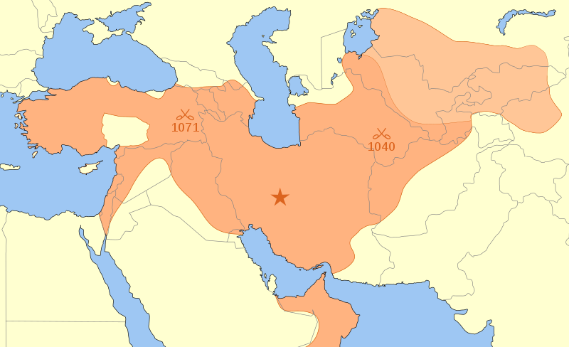
English: A map showing the Great Seljuk Empire at its height, upon the death of Malik Shah I in 1092.
Nederlands: Het Seltsjoekenrijk op het toppunt van haar macht in nl:1092, ten tijde van de dood van nl:Malik Sjah I. Na diens dood viel het rijk uiteen in verschillende staatjes. |
| Ji̍t-kî | |
| Chhut-chhù | Ka-tī chò--ê |
| Chok-chiá | MapMaster |
References
- Black, Jeremy 《 The Atlas of World History》, Covent Garden Books, American Edition, New York, 第p. 228頁 , ISBN 9780756618612
- Grousset, René (1970) The Empire of the Steppes: A History of Central Asia, New Brunswick:Rutgers University Press, 8th paperback edition, 2002, p. 156.
- Hall, Simon and John Haywood (1997) The Complete Atlas of World History: The Medieval & Early Modern World, A.D. 600 - 1783, Armonk, NY: Sharpe Reference.
- Holt, Peter Malcolm; Ann K. S. Lambton; Bernard Lewis (1977) The Cambridge history of Islam, Volume 1, p, 260, ISBN 978-0521291354.
- Hourani, Albert (1991) A History of the Arab Peoples, Cambridge, Massachusetts: The Belknap Press of Harvard University Press, p. 467.
- Shepherd, William (1911) "Europe and the Mediterranean Lands about 1097", Historical Atlas, New York: Henry Holt and Company.
In general, the map was based on Shepherd and on Hall & Haywood, with modifications based on Grousset and Hourani (Hourani's map excludes the area retaken by Byzantium and the Crusaders in 1097-1100). Other maps show the Empire extending into present day Pakistan &/or that include Mecca, but I have found little evidence to support this.
Siū-khoân
我,本作品的著作權持有者,決定用以下授權條款發佈本作品:

|
Siū-khuân hōo lí i-tsiàu Tsū-iû Nńg-thé Ki-kim-huē huat-pòo ê bô kòo-tīng bûn-jī, hong-bīn bûn-jī kah hong-té bûn-jīGNU Tsū-iû Bûn-kiānn Siū-khuân Tiâu-khuán1.2 pán ia̍h-sī koh-lâi ê jīm-ì pán-pún, tuì pún tóng-àn tsìn-hîng hok-tsè, thuân-pòo, kah/ia̍h-sī siu-kái.Tsit-ê hia̍p-gī ê hù-pún khǹg tī GNU Tsū-iû Bûn-kiānn Siū-khuân Tiâu-khuán tang-tiong.http://www.gnu.org/copyleft/fdl.htmlGFDLGNU Free Documentation Licensetruetrue |
- Lí ē-sái tsū-iû:
- hun-hióng – kho͘-pih, hoat-pò͘ kap thoân-pò͘ pún chok
- tiông-sin siu-kái – kái-pian pún chok-phín
- Àn i-hā ê tiâu-kiāⁿ
- Piau-sī miâ-sìnn – Lí ài siá-bîng tsìng-khak ê miâ-hō, ū siū-khuân tiâu-khuán ê liân-kiat, iáu-koh-ū lí tsuè siánn-mih ê kái-piàn. Lí ē-tàng tī jīm-hô ha̍p-lí ê hong-sik tsìn-hîng, m̄-kò buē-tàng ti̍t-tsiap kóng siū-khuân hōo lí ia̍h-sī lí sú-iōng.
- Kâng-khuán hong-sik hun-hióng – Lí nā kái-tōng, piàn-khoán, he̍k-chiá kun-kù pún chok chhòng-chō, lí kaⁿ-taⁿ ē-tàng ēng kap pún chok kâng-khoán he̍k-chiá saⁿ-chhiūⁿ ê hí-khó lâi hoat-pò͘ chò--chhut-lâi ê chok-phín.
Lí ē-tàng suán-ti̍k lí su-iàu ê siū-khuân tiâu-khuán.
說明
添加單行說明來描述出檔案所代表的內容
گستردگی مرزهای ایران در دورهٔ سلجوقیان در زمان مرگ سلطان ملک شاه.
在此檔案描寫的項目
描繪內容 繁體中文
授權條款 繁體中文
10 3 2008
多媒體型式 繁體中文
image/svg+xml
檔案歷史
揤日期/時間,看彼時陣的檔案.
| 日期/ 時間 | 細張圖 | 寸尺 | 用者 | 註解 | |
|---|---|---|---|---|---|
| 現在 | 2014年6月5日 (拜4) 13:24 |  | 800 × 488(161 KB) | wikimediacommons>Ras67 | frame removed |
影像連結
以下的頁連到這个影像:
元資料
這个檔案有伊的資訊,可能是相機抑掃描機用的。
若改過這个檔案,資訊就無完全對著。
| 寬度 | 800 |
|---|---|
| 高度 | 488 |