tóng-àn:Shetland UK relief location map.jpg
跳至導覽
跳至搜尋

先看佔量: 315 × 599 像素. 其他的 kái-sek-tō͘: 126 × 240 像素 | 252 × 480 像素 | 404 × 768 像素 | 538 × 1,024 像素 | 1,999 × 3,802 像素.
全解析度 (1,999 × 3,802 像素,檔案佔量: 505 KB,MIME類型: image/jpeg)
|
|
這是對Wikimedia Commons引來的一份檔案。伊佇hia ê kì-su̍t-ia̍h頂面的資訊顯示對下底. |
| Soat-bêng |
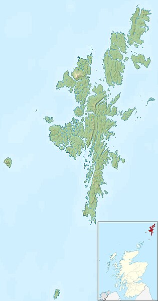
Relief map of the Shetland Islands, UK. Equirectangular map projection on WGS 84 datum, with N/S stretched 200% Geographic limits:
|
| Ji̍t-kî | |
| Chhut-chhù |
|
| Chok-chiá | Nilfanion, created using Ordnance Survey data |
| Siū-khuân ún-tsún (Koh iōng tsit-ê tóng-àn) |
Tsit-ê tóng-àn sī iōng Tshòng-iōng CC Kâng-khuán hong-sik hun-hióng 3.0 bī tsāi-tuē pán-pún siū-khuân tiâu-khuán. Piau-sī miâ-sìnn: Contains Ordnance Survey data © Crown copyright and database right
|
| 其他版本 | File:Shetland UK blank map.svg - Blank map |
檔案歷史
揤日期/時間,看彼時陣的檔案.
| 日期/ 時間 | 細張圖 | 寸尺 | 用者 | 註解 | |
|---|---|---|---|---|---|
| 現在 | 2011年11月30日 (拜3) 12:29 | | 1,999 × 3,802(505 KB) | wikimediacommons>Nilfanion | {{Information |Description=Relief map of the Shetland Islands, UK. Equirectangular map projection on WGS 84 datum, with N/S stretched 200% Geographic limits: *West: 2.15W *East: 0.70W *North: 60.88N *South: 59.50N |Source=[[w:Ordn |
影像連結
以下的頁連到這个影像: