tóng-àn:Sunda Strait map-fr.svg
跳至導覽
跳至搜尋

此 SVG 檔案的 PNG 預覽的大小:800 × 535 像素。 其他的 kái-sek-tō͘: 320 × 214 像素 | 640 × 428 像素 | 1,024 × 685 像素 | 1,280 × 857 像素 | 2,560 × 1,713 像素 | 3,579 × 2,395 像素.
全解析度 (SVG ùng-giông, chék-cháung: 3,579 × 2,395 chuông-só, ùng-giông duâi-nâung:2.08 MB)
|
|
這是對Wikimedia Commons引來的一份檔案。伊佇hia ê kì-su̍t-ia̍h頂面的資訊顯示對下底. |
Khài-iàu
| Soat-bêng |
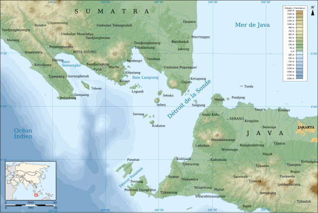
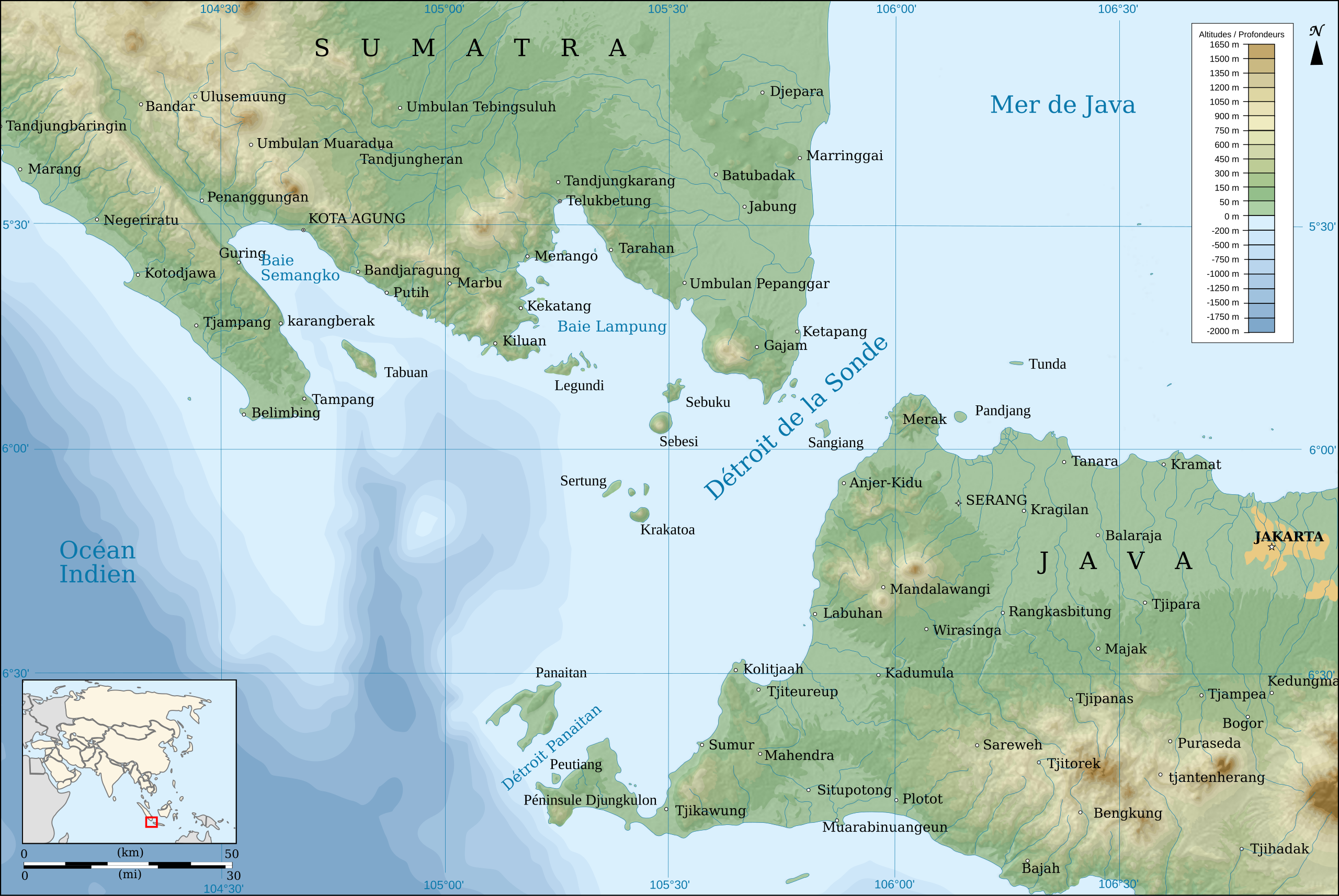
English: Map of the Sunda Strait, in french.
Français : Carte du Détroit de la Sonde, en français. |
||
| Ji̍t-kî | |||
| Chhut-chhù |
travail personnel. Source :
|
||
| Chok-chiá | Pinpin | ||
| 其他版本 | |||
| SVG | W3C-validity not checked.
|
||
| Graphic Lab |

| 拍攝地點 | | 位於此地的本圖片與其他圖片: OpenStreetMap |
|---|
Siū-khoân
我,本作品的著作權持有者,決定用以下授權條款發佈本作品:
| 公共版權:本藝術作品是自由的,您可以依據自由藝術作品許可協議的條款傳播和/或修改本藝術作品。您可以在Copyleft Attitude網站或其他網站找到該許可協議的樣本。 |
- Lí ē-sái tsū-iû:
- hun-hióng – kho͘-pih, hoat-pò͘ kap thoân-pò͘ pún chok
- tiông-sin siu-kái – kái-pian pún chok-phín
- Àn i-hā ê tiâu-kiāⁿ
- Piau-sī miâ-sìnn – Lí ài siá-bîng tsìng-khak ê miâ-hō, ū siū-khuân tiâu-khuán ê liân-kiat, iáu-koh-ū lí tsuè siánn-mih ê kái-piàn. Lí ē-tàng tī jīm-hô ha̍p-lí ê hong-sik tsìn-hîng, m̄-kò buē-tàng ti̍t-tsiap kóng siū-khuân hōo lí ia̍h-sī lí sú-iōng.
- Kâng-khuán hong-sik hun-hióng – Lí nā kái-tōng, piàn-khoán, he̍k-chiá kun-kù pún chok chhòng-chō, lí kaⁿ-taⁿ ē-tàng ēng kap pún chok kâng-khoán he̍k-chiá saⁿ-chhiūⁿ ê hí-khó lâi hoat-pò͘ chò--chhut-lâi ê chok-phín.
Lí ē-tàng suán-ti̍k lí su-iàu ê siū-khuân tiâu-khuán.
檔案歷史
揤日期/時間,看彼時陣的檔案.
| 日期/ 時間 | 細張圖 | 寸尺 | 用者 | 註解 | |
|---|---|---|---|---|---|
| 現在 | 2018年12月24日 (拜1) 12:40 | | 3,579 × 2,395(2.08 MB) | wikimediacommons>Sémhur | Scale correction. |
影像連結
以下的頁連到這个影像: