tóng-àn:Union Pacific Railroad system map.svg
跳至導覽
跳至搜尋

此 SVG 檔案的 PNG 預覽的大小:800 × 457 像素。 其他的 kái-sek-tō͘: 320 × 183 像素 | 640 × 366 像素 | 1,024 × 585 像素 | 1,280 × 731 像素 | 1,400 × 800 像素.
全解析度 (SVG ùng-giông, chék-cháung: 1,400 × 800 chuông-só, ùng-giông duâi-nâung:1.56 MB)
|
|
這是對Wikimedia Commons引來的一份檔案。伊佇hia ê kì-su̍t-ia̍h頂面的資訊顯示對下底. |
Khài-iàu
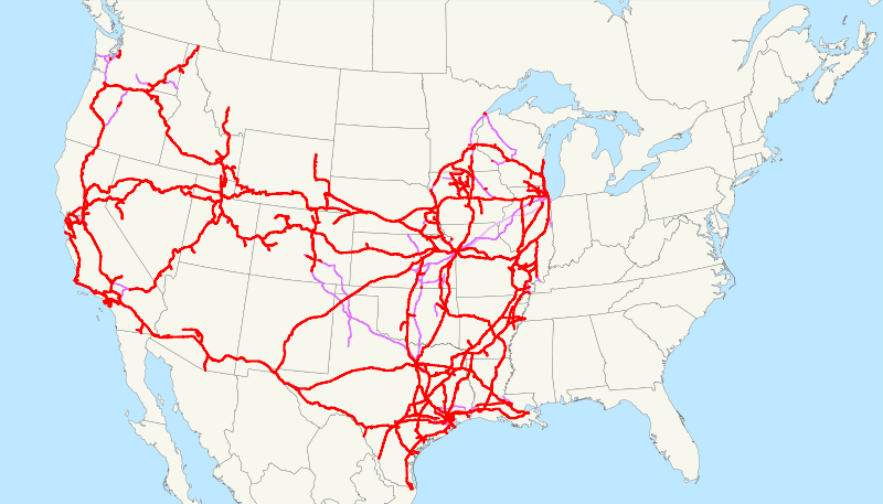
| Soat-bêng | This is a map of the Union Pacific Railroad as of 2008, with trackage rights in purple (the special Chicago-Kansas City intermodal trackage rights are lighter). Email me if you would like a copy of the GIS data I created (modified from Bureau of Transportation Statistics North American Transportation Atlas Data) or if you see any errors. |
| Ji̍t-kî | 2008年8-goe̍h26日 (原始上傳日期) |
| Chhut-chhù | No machine-readable source provided. Own work assumed (based on copyright claims). |
| Chok-chiá | No machine-readable author provided. NE2 assumed (based on copyright claims). |
Siū-khoân
| 我,此作品的版權所有人,釋出此作品至公共領域。此授權條款在全世界均適用。 這可能在某些國家不合法,如果是的話: 我授予任何人有權利使用此作品於任何用途,除受法律約束外,不受任何限制。 |
檔案歷史
揤日期/時間,看彼時陣的檔案.
| 日期/ 時間 | 細張圖 | 寸尺 | 用者 | 註解 | |
|---|---|---|---|---|---|
| 現在 | 2009年3月18日 (拜3) 12:52 | | 1,400 × 800(1.56 MB) | NE2 | Verifying that nothing has gotten screwed up. |