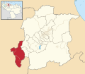
tóng-àn:Venezuela - Yaracuy - Peña.svg

全解析度 (SVG ùng-giông, chék-cháung: 512 × 448 chuông-só, ùng-giông duâi-nâung:1.86 MB)
|
|
這是對Wikimedia Commons引來的一份檔案。伊佇hia ê kì-su̍t-ia̍h頂面的資訊顯示對下底. |
Bo̍k-lo̍k
Khài-iàu
![]() 此SVG地图是使用广域位置地图方案的一系列定位器地图的一部分。您可以通过根类别来查看更多详细信息。
此SVG地图是使用广域位置地图方案的一系列定位器地图的一部分。您可以通过根类别来查看更多详细信息。
定位器地圖設計準則 ▼ | |
|---|---|
準則
設計指南基於▸ 德國地圖商店的位置地圖設計(德文)。推薦基於現有位置地圖創作新定位地圖。此情況下,請保持尺寸合比例不變。以保持其可重複利用(▸指导)。標記顏色需要為深紅色,水體推薦為透明,以更好標及其他元素。請注意,本指南僅供參考,這不是強制性要求!
標記小區域
海外區域和小地圖
關於迷你地圖所顯示的區域的實際位置,請參見▸位置圖模板(德文)和▸位置圖模板(法文),在每張圖中插入小世界地圖。
爭議地區
灰色標註特殊元素
有背景的地圖
|
Map legend
- C12836 → Marked administrative territory
- FDFBEA → Marked state/province
- F6E1B9 → Other state/provinces of Venezuela
- 656564 → Lines/boundaries
Mini map legend
- C12836 → Marked state/province, and red circle
- FDFBEA → Rest of Venezuela
- DFDFDF → Other countries
- 656564 → Lines/boundaries
- C7E7FB → Water
- 000000 → Mini map border box
Geographic limits of the map (EPSG:4326)
- N: 10.8050
- S: 9.7751
- W: 69.3702
- E: 68.1746
Siū-khoân
| 描寫文Venezuela - Yaracuy - Peña.svg |
English: Locator map of Municipio Peña; in Yaracuy, Venezuela |
|||||||||
| SVG開發 InfoField | 本向量圖形使用Adobe Illustrator創作。 |
|||||||||
| Ji̍t-kî | ||||||||||
| Chhut-chhù | OpenStreetMap data, extracted via QGIS software. | |||||||||
| 創作作者 |
OpenStreetMap contributors |
|||||||||
| Siū-khuân ún-tsún (Koh iōng tsit-ê tóng-àn) |
OpenStreetMap data is available under the Open Database License (details). Standard style map tiles are licensed as ODbL Produced Works.
|
|||||||||
| Geotemporal data | ||||||||||
| 邊框 |
|
|||||||||
| Boundaries geometry from OpenStreetMap has been simplified to optimize its indexing in Wikimedia projects. The boundaries lines shown in this image may be of lower quality than those shown in OpenStreetMap project, or in real life. |
說明
在此檔案描寫的項目
描繪內容 繁體中文
創作作者 繁體中文
沒有Wikidata項目的某些值
授權條款 繁體中文
創用CC姓名標示-相同方式分享4.0國際 繁體中文
開放資料庫授權 繁體中文
29 8 2017
資料大小 繁體中文
1,951,096 Byte
高度 繁體中文
448 ōe-sò͘
寬度 繁體中文
512 ōe-sò͘
多媒體型式 繁體中文
image/svg+xml
檔案歷史
揤日期/時間,看彼時陣的檔案.
| 日期/ 時間 | 細張圖 | 寸尺 | 用者 | 註解 | |
|---|---|---|---|---|---|
| 現在 | 2023年7月27日 (拜4) 12:55 |  | 512 × 448(1.86 MB) | wikimediacommons>Wguayana | OpenStreetMap 2023 data |
影像連結
以下的頁連到這个影像:
元資料
這个檔案有伊的資訊,可能是相機抑掃描機用的。
若改過這个檔案,資訊就無完全對著。
| 簡稱 | Municipio Peña - Yaracuy - Venezuela |
|---|---|
| 寬度 | 100% |
| 高度 | 100% |


