tóng-àn:Yalurivermap.png
跳至導覽
跳至搜尋


先看佔量: 600 × 600 像素. 其他的 kái-sek-tō͘: 240 × 240 像素 | 480 × 480 像素 | 1,000 × 1,000 像素.
全解析度 (1,000 × 1,000 像素,檔案佔量: 275 KB,MIME類型: image/png)
|
|
這是對Wikimedia Commons引來的一份檔案。伊佇hia ê kì-su̍t-ia̍h頂面的資訊顯示對下底. |
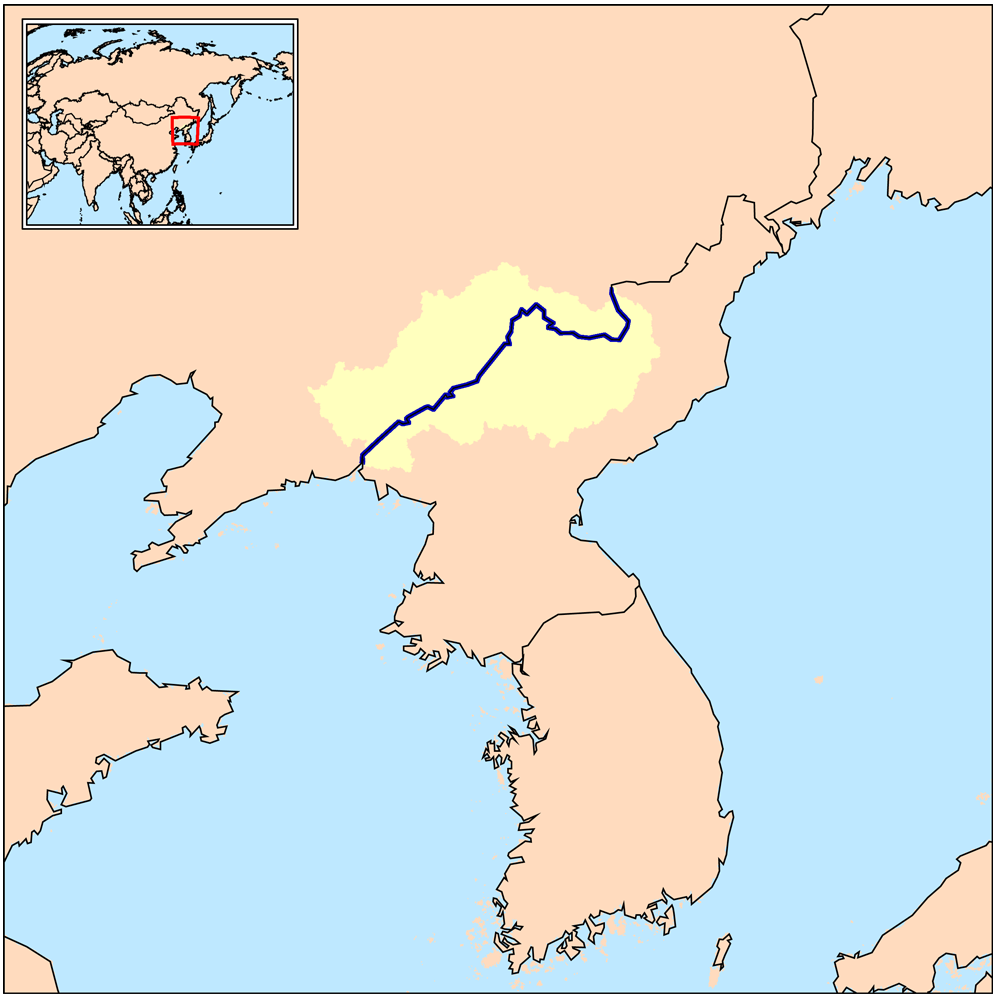
| Soat-bêng | This is a map of the Yalu River drainage basin - in China and North Korea. |
| Ji̍t-kî | |
| Chhut-chhù | Own work using Digital Chart of the World and GTOPO data. |
| Chok-chiá | Kmusser |
我,本作品的著作權持有者,決定用以下授權條款發佈本作品:
此檔案採用創用CC 姓名標示-相同方式分享 3.0 未在地化版本授權條款。
- 你會使自由:
- 分享 – kho͘-pih, hoat-pò͘ kap thoân-pò͘ pún chok
- 重新修改 – kái-pian pún chok-phín
- Àn i-hā ê tiâu-kiāⁿ
- 標示名姓 – 您必須指名出正確的製作者,和提供授權條款的連結,以及表示是否有對內容上做出變更。您可以用任何合理的方式來行動,但不得以任何方式表明授權條款是對您許可或是由您所使用。
- 仝款方式方享 – Lí nā kái-tōng, piàn-khoán, he̍k-chiá kun-kù pún chok chhòng-chō, lí kaⁿ-taⁿ ē-tàng ēng kap pún chok kâng-khoán he̍k-chiá saⁿ-chhiūⁿ ê hí-khó lâi hoat-pò͘ chò--chhut-lâi ê chok-phín.
檔案歷史
揤日期/時間,看彼時陣的檔案.
| 日期/ 時間 | 細張圖 | 寸尺 | 用者 | 註解 | |
|---|---|---|---|---|---|
| 現在 | 2009年3月27日 (拜5) 02:42 | | 1,000 × 1,000(275 KB) | Kmusser | {{Information |Description=This is a map of the Yalu River drainage basin. |Source=Own work using [http://www.maproom.psu.edu/dcw/ Digital Chart of the World] and [http://edc.usgs.gov/products/elevation/gtopo30/gtopo30.html GTOPO] dat |
影像連結
以下的頁連到這个影像: