tóng-àn:Yuandadu map.jpg
跳至導覽
跳至搜尋


先看佔量: 454 × 599 像素. 其他的 kái-sek-tō͘: 182 × 240 像素 | 591 × 780 像素.
全解析度 (591 × 780 像素,檔案佔量: 58 KB,MIME類型: image/jpeg)
|
|
這是對Wikimedia Commons引來的一份檔案。伊佇hia ê kì-su̍t-ia̍h頂面的資訊顯示對下底. |
Khài-iàu
| Soat-bêng |
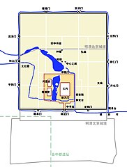
中文:元大都平面图,与明清京城地图相比
English: Map of Khanbaliq, the ancient city of Beijing in Yuan Dynasty, compared with capital in Ming and Qing Dynasty |
| Ji̍t-kî | 2006年11-goe̍h27日 (原始上傳日期) |
| Chhut-chhù | Transferred from zh.wikipedia to Commons. |
| Chok-chiá | 中文Wikipedia的Kallgan |


Siū-khoân
| 我,此作品的版權所有人,釋出此作品至公共領域。此授權條款在全世界均適用。 這可能在某些國家不合法,如果是的話: 我授予任何人有權利使用此作品於任何用途,除受法律約束外,不受任何限制。 |
原始上傳日誌
The original description page was here. All following user names refer to zh.wikipedia.
- 2006-11-27 08:38 Kallgan 591×780×8 (59032 bytes) {{subst:Information| |A= [[元大都]]平面 |B= 原创 |C= 2006年11月27日 |D= [[user:kallgan]] |E= {{PD-self}} |F= 档案其他版本(选填) }}
檔案歷史
揤日期/時間,看彼時陣的檔案.
| 日期/ 時間 | 細張圖 | 寸尺 | 用者 | 註解 | |
|---|---|---|---|---|---|
| 現在 | 2006年12月1日 (拜5) 00:43 | | 591 × 780(58 KB) | Shizhao | {{Information |Description=zh:元大都平面 |Source=Originally from [http://zh.wikipedia.org zh.wikipedia]; description page is/was [http://zh.wikipedia.org/w/index.php?title=Image%3AYuandadu_map.jpg here]. |Date=2006-11-27 (original upload date) | |
影像連結
以下的頁連到這个影像: