tóng-àn:506-Castile 1210.png
跳至導覽
跳至搜尋


無較權的解析度.
506-Castile_1210.png (474 × 506 像素,檔案佔量: 138 KB,MIME類型: image/png)
|
|
這是對Wikimedia Commons引來的一份檔案。伊佇hia ê kì-su̍t-ia̍h頂面的資訊顯示對下底. |
Khài-iàu
| Soat-bêng |
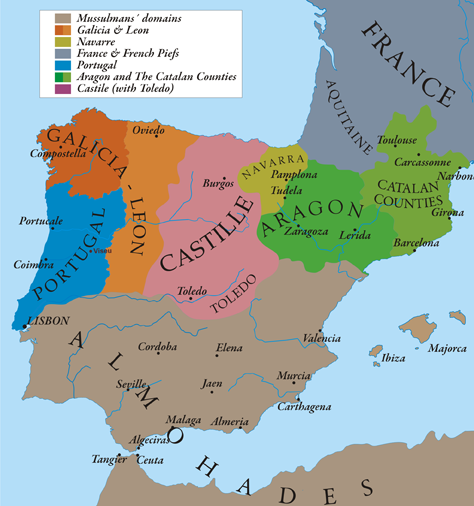
English: This map show Al-Andalus (Almohades) and European Christian kingdoms. 12th-13th centuries. It´s made from "The Historical Atlas by William R. Shepherd, 1926". |
| Ji̍t-kî | 7/05/2010 |
| Chhut-chhù | Ka-tī chò--ê |
| Chok-chiá | Alexandre Vigo |
| 授權允准 (Bô siŏh-huòi sāi ciā ùng-giông) |
Texas University |
| 其他版本 | http://www.lib.utexas.edu/maps/historical/spanish_kingdoms_1210.jpg |

|
本圖片是以PNG、GIF或JPEG格式上傳。然而,其中包含的資料或訊息,應該重新建立成可縮放向量圖形(SVG)檔案,以更有效率或更準確的方式儲存。如有可能,請上傳本圖片的SVG格式版本。在上傳之後,請修改維基各姊妹計畫中所有使用舊版圖片的條目(列在圖像連結章節中),替換為新版圖片,並在舊圖片的描述頁中加入{{Vector version available|新圖片名稱.svg}}模板,同時移除本模板。
|
Siū-khoân
我,本作品的著作權持有者,決定用以下授權條款發佈本作品:

|
已授權您依據自由軟體基金會發行的無固定段落、封面文字和封底文字GNU自由文件授權條款1.2版或任意後續版本,對本檔進行複製、傳播和/或修改。該協議的副本列在GNU自由文件授權條款中。 |
此檔案採用創用CC 姓名標示-相同方式分享 3.0 未在地化版本授權條款。
- 你會使自由:
- 分享 – kho͘-pih, hoat-pò͘ kap thoân-pò͘ pún chok
- 重新修改 – kái-pian pún chok-phín
- Àn i-hā ê tiâu-kiāⁿ
- 標示名姓 – 您必須指名出正確的製作者,和提供授權條款的連結,以及表示是否有對內容上做出變更。您可以用任何合理的方式來行動,但不得以任何方式表明授權條款是對您許可或是由您所使用。
- 仝款方式方享 – Lí nā kái-tōng, piàn-khoán, he̍k-chiá kun-kù pún chok chhòng-chō, lí kaⁿ-taⁿ ē-tàng ēng kap pún chok kâng-khoán he̍k-chiá saⁿ-chhiūⁿ ê hí-khó lâi hoat-pò͘ chò--chhut-lâi ê chok-phín.
Nṳ̄ buóh dĭk sié-nó̤h sêu-guòng dèu-kuāng dŭ kō̤-ī gēng.
檔案歷史
揤日期/時間,看彼時陣的檔案.
| 日期/ 時間 | 細張圖 | 寸尺 | 用者 | 註解 | |
|---|---|---|---|---|---|
| 現在 | 2010年5月13日 (拜4) 04:58 | | 474 × 506(138 KB) | Alexandre Vigo~commonswiki | {{Information |Description={{en|1=This map show Al-Andalus (Almohades) and European Christian kingdoms. 12th-13th centuries. It´s made from "The Historical Atlas by William R. Shepherd, 1926".}} |Source={{own}} |Author=[[User:Alexandre Vigo|Alexandre Vig |
影像連結
以下的頁連到這个影像: