tóng-àn:Adyar estuary.jpg
跳至導覽
跳至搜尋

先看佔量: 800 × 364 像素. 其他的 kái-sek-tō͘: 320 × 146 像素 | 640 × 291 像素 | 1,443 × 657 像素.
全解析度 (1,443 × 657 像素,檔案佔量: 249 KB,MIME類型: image/jpeg)
|
|
這是對Wikimedia Commons引來的一份檔案。伊佇hia ê kì-su̍t-ia̍h頂面的資訊顯示對下底. |
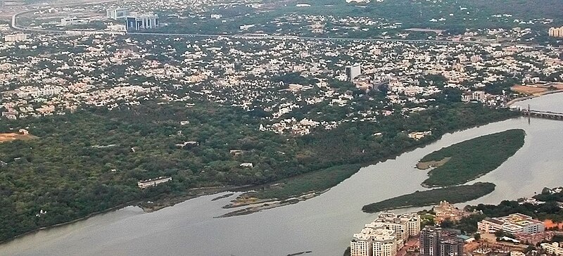
| Soat-bêng | Aerial view of the Adyar Estuary and w:Adyar. On the top ind is w:Tidel Park and the w:Chennai MRTS. The gardens belong to the w:Theosophical Society. | ||
| Ji̍t-kî | 22 June 05 | ||
| Chhut-chhù | Ka-tī chò--ê | ||
| Chok-chiá |
|
||
| Siū-khuân ún-tsún (Koh iōng tsit-ê tóng-àn) |
我,本作品的著作權持有者,決定用以下授權條款發佈本作品: 此檔案採用創用CC 姓名標示-相同方式分享 2.5 通用版授權條款。
|
| 拍攝地點 | | 位於此地的本圖片與其他圖片: OpenStreetMap |
|---|
檔案歷史
揤日期/時間,看彼時陣的檔案.
| 日期/ 時間 | 細張圖 | 寸尺 | 用者 | 註解 | |
|---|---|---|---|---|---|
| 現在 | 2007年4月28日 (拜6) 12:16 | | 1,443 × 657(249 KB) | wikimediacommons>Planemad | {{Information |Description=Aerial view of the Adyar Estuary and w:Adyar. On the top ind is w:Tidel Park and the w:Chennai MRTS. |Source=own work |Date= 22 June 05 |Author= w:user:PlaneMad |Permission={{self|cc-by-sa-2.5}} |
影像連結
以下的頁連到這个影像: