tóng-àn:Arcadia Round Barn (NRHP).jpg
跳至導覽
跳至搜尋

先看佔量: 799 × 599 像素. 其他的 kái-sek-tō͘: 320 × 240 像素 | 640 × 480 像素 | 881 × 661 像素.
全解析度 (881 × 661 像素,檔案佔量: 78 KB,MIME類型: image/jpeg)
|
|
這是對Wikimedia Commons引來的一份檔案。伊佇hia ê kì-su̍t-ia̍h頂面的資訊顯示對下底. |
.jpg)
Khài-iàu
| Soat-bêng |
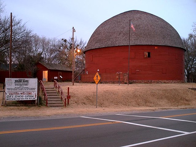
English: The Arcadia Round Barn is a site on the National Register of Historic Places and is located in Arcadia on Route 66. This photo was taken on the south side of Route 66 looking north. |
| Ji̍t-kî | 攝於2005年11-goe̍h19日 |
| Chhut-chhù | Transferred from en.wikipedia |
| Chok-chiá | DBinfo at en.wikipedia |
| 目標地點 | | 位於此地的本圖片與其他圖片: OpenStreetMap |
|---|
.jpg¶ms=035.662222_N_-097.325556_E_globe:Earth_class:object_region:US_type:landmark_scale:1500_&language=nan)
Siū-khoân
| 此作品已由其作者,英文Wikipedia的DBinfo,釋出至公有領域。此授權條款在全世界均適用。 這可能在某些國家不合法,如果是的話: DBinfo授予任何人有權利使用此作品於任何用途,除受法律約束外,不受任何限制。 |
原始上傳日誌
The original description page was here. All following user names refer to en.wikipedia.
- 2006-04-30 05:27 DBinfo 881×661×8 (80172 bytes) The [[Arcadia Round Barn]] is a site on the [[National Register of Historic Places]] and is located in [[Arcadia, OK]] on [[Route 66]]. This photo was taken on the south side of Route 66 looking north on [[November 19, 2005]].
檔案歷史
揤日期/時間,看彼時陣的檔案.
| 日期/ 時間 | 細張圖 | 寸尺 | 用者 | 註解 | |
|---|---|---|---|---|---|
| 現在 | 2008年5月8日 (拜4) 20:37 | | 881 × 661(78 KB) | wikimediacommons>File Upload Bot (Magnus Manske) | {{BotMoveToCommons|en.wikipedia}} {{Information |Description={{en|The en:Arcadia Round Barn is a site on the en:National Register of Historic Places and is located in en:Arcadia, OK on en:Route 66. This photo was taken on the south s |
影像連結
以下的頁連到這个影像:
.jpg)