tóng-àn:Chugwater Soda Fountain.jpg

全解析度 (4,000 × 3,000 像素,檔案佔量: 2.66 MB,MIME類型: image/jpeg)
|
|
這是對Wikimedia Commons引來的一份檔案。伊佇hia ê kì-su̍t-ia̍h頂面的資訊顯示對下底. |
Khài-iàu
| Soat-bêngChugwater Soda Fountain.jpg |
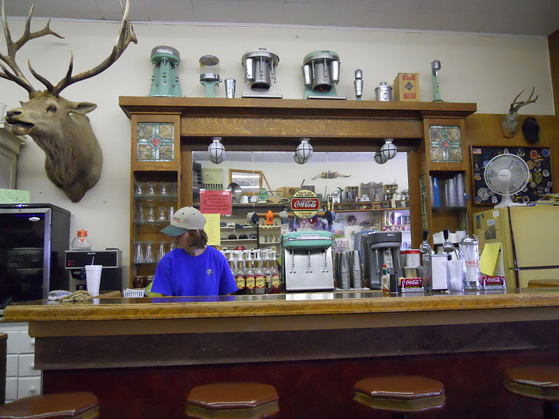
The History of the Chugwater Soda Fountain The Oldest Operating Soda fountain in Wyoming The Soda fountain is housed in one of the oldest buildings in Chugwater. The building was built in 1914, later, partially burned down, and was rebuilt in 1916. It has been a Doctor's office and a pharmacy. There was a small apartment in the back where the doctor and his family lived. The pharmacy drawers are still intact along one wall of the store. The soda fountain bar was built in England and installed in a business in Rock Creek WY. when the Railroad went through in 1927, the town moved to Tock River. The owner was not interested in moving his business, so he sold his equipment to the owner of the pharmacy in Chugwater. The bar was broken aprt into three pieces - the main bar, the top(including the mirror), and the bottom cabinets. It was then packed into wagons and transported over the mountains to be installed in this building. The mirror and glass are all original; you can stand in the back and see the curve in the mirror.1 The pharmacy and soda fountain co-existed for some time, but eventually one of the owners no longer had a pharmacy license and the store became a soda fountain only. Ownership has changed hands many times, with different people making various changes. The large elk overlooking the room is nicknamed "Wendall" for the man who shot him. He was shot near Jackson, WY in 1946 and has resided in the soda fountain since 1947. A town petition prevents Wendall from leaving, no matter who owns it. Over time, different owners have added components like the small package liquor store, "diner", and the Beer Garden in the summer. It remains one of few active soda fountains in the state that serves traditional, hand dipped ice cream shakes and malts. |
| Ji̍t-kî | |
| Chhut-chhù | Chugwater Soda Fountain |
| Chok-chiá | Konrad Summers from Santa Clarita (Valencia) , California, USA |
| 拍攝地點 | 41° 45′ 25.83″ 北, 104° 49′ 15.63″ 西 | 位於此地的本圖片與其他圖片: OpenStreetMap |
|---|
Siū-khoân
- Lí ē-sái tsū-iû:
- hun-hióng – kho͘-pih, hoat-pò͘ kap thoân-pò͘ pún chok
- tiông-sin siu-kái – kái-pian pún chok-phín
- Àn i-hā ê tiâu-kiāⁿ
- Piau-sī miâ-sìnn – Lí ài siá-bîng tsìng-khak ê miâ-hō, ū siū-khuân tiâu-khuán ê liân-kiat, iáu-koh-ū lí tsuè siánn-mih ê kái-piàn. Lí ē-tàng tī jīm-hô ha̍p-lí ê hong-sik tsìn-hîng, m̄-kò buē-tàng ti̍t-tsiap kóng siū-khuân hōo lí ia̍h-sī lí sú-iōng.
- Kâng-khuán hong-sik hun-hióng – Lí nā kái-tōng, piàn-khoán, he̍k-chiá kun-kù pún chok chhòng-chō, lí kaⁿ-taⁿ ē-tàng ēng kap pún chok kâng-khoán he̍k-chiá saⁿ-chhiūⁿ ê hí-khó lâi hoat-pò͘ chò--chhut-lâi ê chok-phín.
| 這幅圖片原始出處為Flickr的https://www.flickr.com/photos/12806074@N08/4712851275 ,作者為tkksummers 。經機器人FlickreviewR在2015年7-goe̍h14日審查後確定為採用cc-by-sa-2.0的協議授權使用。 |
2015年7-goe̍h14日
說明
在此檔案描寫的項目
描繪內容 繁體中文
創作作者 繁體中文
沒有Wikidata項目的某些值
授權條款 繁體中文
13 6 2010
視角坐標 繁體中文
41°45'25.830"N, 104°49'15.625"W
檔案來源 Chinese (Taiwan) (已轉換拼寫)
多媒體型式 繁體中文
image/jpeg
資料大小 繁體中文
2,788,579 Byte
高度 繁體中文
3,000 ōe-sò͘
寬度 繁體中文
4,000 ōe-sò͘
檔案歷史
揤日期/時間,看彼時陣的檔案.
| 日期/ 時間 | 細張圖 | 寸尺 | 用者 | 註解 | |
|---|---|---|---|---|---|
| 現在 | 2015年7月14日 (拜2) 21:22 |  | 4,000 × 3,000(2.66 MB) | wikimediacommons>Tillman | Transferred from Flickr via Flickr2Commons |
影像連結
以下的頁連到這个影像:
元資料
這个檔案有伊的資訊,可能是相機抑掃描機用的。
若改過這个檔案,資訊就無完全對著。
| 相機製造商 | NIKON |
|---|---|
| 相機型號 | COOLPIX S570 |
| 方位 | 標準 |
| 水平解像度 | 300 dpi |
| 垂直解像度 | 300 dpi |
| 使用的軟體 | COOLPIX S570V1.0 |
| 檔案改變的日子佮時間 | 2010年6月13日 (禮拜) 01:12 |
| 亮度與彩度位置 | 同時取樣 |
| 曝光時間 | 1/100 秒 (0.01) |
| 光圈值 | f/2.7 |
| 曝光模式 | 標準模式 |
| ISO 速率 | 800 |
| Exif 版本 | 2.2 |
| 資料產生的日期時間 | 2010年6月13日 (禮拜) 01:12 |
| 數位化的日期時間 | 2010年6月13日 (禮拜) 01:12 |
| 每像素內含 |
|
| 影像壓縮模式 | 2 |
| APEX 曝光補償 | 0 |
| 最大陸地光圈 | 2.9 APEX(f/2.73) |
| 測光模式 | 模式 |
| 光源 | 不明 |
| 閃光燈 | 閃光燈未開啟, 自動模式 |
| 焦距 | 5毫米 |
| 支援的 Flashpix 版本 | 1 |
| 色彩空間 | sRGB |
| 檔案來源 | 數位相機 |
| 場景類型 | 直接照像圖片 |
| 自訂影像處理 | 一般程序 |
| 曝光模式 | 自動曝光 |
| 白平衡 | 自動白平衡 |
| 數位變焦比率 | 0 |
| 35 毫米膠片焦距 | 28毫米 |
| 場景拍攝類型 | 人像 |
| 場景控制 | 高增益 |
| 對比度 | 標準 |
| 飽和度 | 標準 |
| 銳利度 | 標準 |
| 主體距離範圍 | 不明 |