這是一份對Wikimedia Commons引來的檔案

tóng-àn:Czechoslovakia01.png

Lohankhapedia (自由的百科全書) 欲共你講..。
跳至導覽 跳至搜尋
全解析度(1,100 × 468 像素,檔案佔量: 63 KB,MIME類型: image/png

File:First Czechoslovak Republic (1928).svg是本檔案的向量版本。 如果品質不低,就應該優先使用該檔案,而非PNG檔案。

File:Czechoslovakia01.png → File:First Czechoslovak Republic (1928).svg

更多資訊請參閱Help:SVG/zh

其他語言
Alemannisch  العربية  беларуская (тарашкевіца)  български  বাংলা  català  нохчийн  čeština  dansk  Deutsch  Ελληνικά  English  British English  Esperanto  español  eesti  euskara  فارسی  suomi  français  Frysk  galego  Alemannisch  עברית  hrvatski  magyar  հայերեն  Bahasa Indonesia  Ido  italiano  日本語  ქართული  한국어  lietuvių  македонски  മലയാളം  Bahasa Melayu  norsk bokmål  Plattdüütsch  Nederlands  norsk nynorsk  norsk  occitan  polski  prūsiskan  português  português do Brasil  română  русский  sicilianu  Scots  slovenčina  slovenščina  српски / srpski  svenska  தமிழ்  ไทย  Türkçe  татарча / tatarça  українська  vèneto  Tiếng Việt  中文  中文(中国大陆)  中文(简体)  中文(繁體)  中文(马来西亚)  中文(新加坡)  中文(臺灣)  中文(臺灣)  +/−
新SVG圖片

Khài-iàu

Soat-bêng
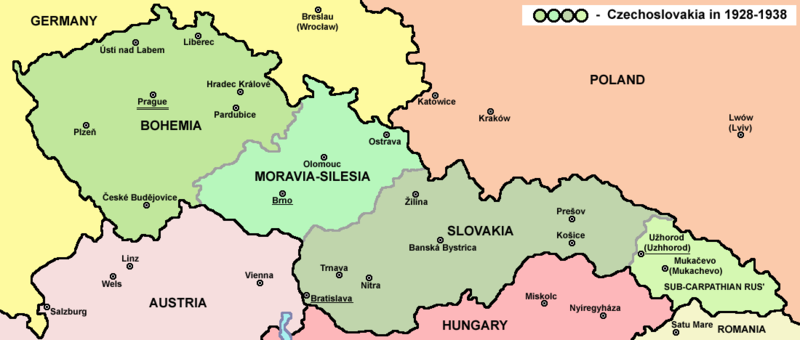
English: Map of Czechoslovakia in 1928-1938. Note: The provinces shown on the map were introduced by Act No. 125/1927 Zb. and became effective in 1928.
Deutsch: Karte der Tschechoslowakei zwischen 1928 und 1938.
Ji̍t-kî
Chhut-chhù

Ka-tī chò--ê Main reference:

Secondary references with similar maps:

Secondary references about Geo-political situation - published sources:

  • The Times History of Europe, Times Books, London, 2002.
  • Richard Overy, The Times History of the 20th Century, Times Books, London, 2004.
  • The Times Atlas svjetske povijesti, Cankarjeva založba, Ljubljana - Zagreb, 1986.
  • Istorijski atlas, Geokarta, Beograd, 1999.
  • Školski istorijski atlas, Zavod za izdavanje udžbenika SR Srbije, Beograd, 1970.
  • Povijesni atlas, Učila - Zagreb, Zagreb, 1971.
  • Povijesni atlas za osnovnu školu, Kartografija - Tlos, Zagreb, 1975.
  • Denis Šehić - Demir Šehić, Istorijski atlas sveta, Beograd, 2007.

Secondary reference about sizable cities:

Chok-chiá

PANONIAN

Atlas This map has been uploaded by Electionworld from en.wikipedia.org to enable the Wikimedia Atlas of the World . Original uploader to en.wikipedia.org was PANONIAN, known as PANONIAN at en.wikipedia.org. Electionworld is not the creator of this map. Licensing information is below.
Siū-khuân ún-tsún
(Koh iōng tsit-ê tóng-àn)
Public domain 我,此作品的版權所有人,釋出此作品至公共領域。此授權條款在全世界均適用。
這可能在某些國家不合法,如果是的話:
我授予任何人有權利使用此作品於任何用途,除受法律約束外,不受任何限制。
其他版本

Derivative works of this file:


說明

添加單行說明來描述出檔案所代表的內容

在此檔案描寫的項目

描繪內容 繁體中文

創作作者 繁體中文

沒有Wikidata項目的某些值

檔案來源 Chinese (Taiwan) (已轉換拼寫)

多媒體型式 繁體中文

image/png

校驗和 繁體中文

bd003d1960e9404724758c8fa7f85ee852d01738

斷定方法 繁體中文: SHA-1 中文 (已轉換拼寫)

資料大小 繁體中文

64,020 Byte

高度 繁體中文

468 ōe-sò͘

寬度 繁體中文

1,100 ōe-sò͘

檔案歷史

揤日期/時間,看彼時陣的檔案.

日期/ 時間細張圖寸尺用者註解
現在2022年7月12日 (拜2) 14:482022年7月12日 (拜2) 14:48版本的細圖1,100 × 468(63 KB)wikimediacommons>Sebastian Wallrothcropped

以下的頁連到這个影像:

元資料