tóng-àn:Kingdoms around Israel 830 map.svg
跳至導覽
跳至搜尋

此 SVG 檔案的 PNG 預覽的大小:502 × 599 像素。 其他的 kái-sek-tō͘: 201 × 240 像素 | 402 × 480 像素 | 644 × 768 像素 | 858 × 1,024 像素 | 1,717 × 2,048 像素 | 720 × 859 像素.
全解析度 (SVG ùng-giông, chék-cháung: 720 × 859 chuông-só, ùng-giông duâi-nâung:122 KB)
|
|
這是對Wikimedia Commons引來的一份檔案。伊佇hia ê kì-su̍t-ia̍h頂面的資訊顯示對下底. |
| Soat-bêng |
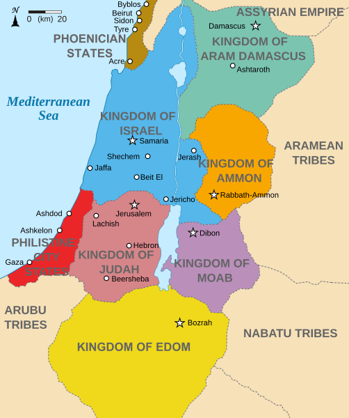
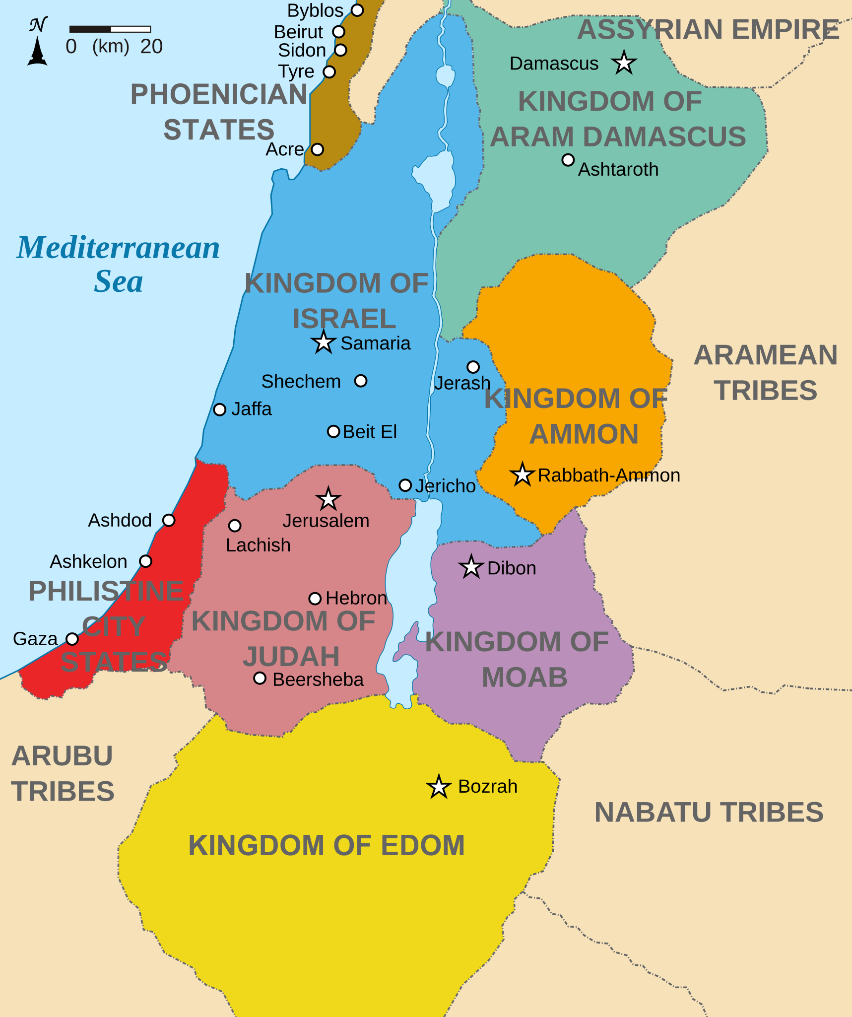
English: Map showing states around Israel & Judah. The Kingdoms around Israel & Judah are colored:
|
| Ji̍t-kî | (UTC) |
| Chhut-chhù | |
| Chok-chiá |
|
| 其他版本 |
[]
|


我,本作品的著作權持有者,決定用以下授權條款發佈本作品:
Tsit-ê tóng-àn sī iōng Tshòng-iōng CC Kâng-khuán hong-sik hun-hióng 3.0 bī tsāi-tuē pán-pún siū-khuân tiâu-khuán.
- Lí ē-sái tsū-iû:
- hun-hióng – kho͘-pih, hoat-pò͘ kap thoân-pò͘ pún chok
- tiông-sin siu-kái – kái-pian pún chok-phín
- Àn i-hā ê tiâu-kiāⁿ
- Piau-sī miâ-sìnn – Lí ài siá-bîng tsìng-khak ê miâ-hō, ū siū-khuân tiâu-khuán ê liân-kiat, iáu-koh-ū lí tsuè siánn-mih ê kái-piàn. Lí ē-tàng tī jīm-hô ha̍p-lí ê hong-sik tsìn-hîng, m̄-kò buē-tàng ti̍t-tsiap kóng siū-khuân hōo lí ia̍h-sī lí sú-iōng.
- Kâng-khuán hong-sik hun-hióng – Lí nā kái-tōng, piàn-khoán, he̍k-chiá kun-kù pún chok chhòng-chō, lí kaⁿ-taⁿ ē-tàng ēng kap pún chok kâng-khoán he̍k-chiá saⁿ-chhiūⁿ ê hí-khó lâi hoat-pò͘ chò--chhut-lâi ê chok-phín.

|
Siū-khuân hōo lí i-tsiàu Tsū-iû Nńg-thé Ki-kim-huē huat-pòo ê bô kòo-tīng bûn-jī, hong-bīn bûn-jī kah hong-té bûn-jīGNU Tsū-iû Bûn-kiānn Siū-khuân Tiâu-khuán1.2 pán ia̍h-sī koh-lâi ê jīm-ì pán-pún, tuì pún tóng-àn tsìn-hîng hok-tsè, thuân-pòo, kah/ia̍h-sī siu-kái.Tsit-ê hia̍p-gī ê hù-pún khǹg tī GNU Tsū-iû Bûn-kiānn Siū-khuân Tiâu-khuán tang-tiong. |
Lí ē-tàng suán-ti̍k lí su-iàu ê siū-khuân tiâu-khuán.
原始上傳日誌
This image is a derivative work of the following images:
- File:Kingdoms_of_Israel_and_Judah_map_830.svg licensed with Cc-by-sa-3.0, GFDL
- 2010-07-13T10:51:49Z Richardprins 720x859 (80858 Bytes) Added colors for the two kingdoms and converted their text to path and arial
- 2010-07-12T23:53:35Z Richardprins 720x859 (63843 Bytes) Shrinked down the borders
- 2010-07-12T19:43:31Z Richardprins 720x859 (63800 Bytes) {{Information |Description={{en|1=Map showing the ancient levant borders and ancient cities such as [[Urmomium]] and [[Jerash]]. The map also shows the region in the 9th century BCE. Notice the coastal land of Philistia, from
Uploaded with derivativeFX
檔案歷史
揤日期/時間,看彼時陣的檔案.
| 日期/ 時間 | 細張圖 | 寸尺 | 用者 | 註解 | |
|---|---|---|---|---|---|
| 現在 | 2022年10月29日 (拜6) 15:32 | | 720 × 859(122 KB) | wikimediacommons>Muchado | Fixing font problems (hopefully) |
影像連結
以下的頁連到這个影像: