tóng-àn:Rail map Scotland West Highland line.png
跳至導覽
跳至搜尋

先看佔量: 480 × 599 像素. 其他的 kái-sek-tō͘: 192 × 240 像素 | 385 × 480 像素 | 615 × 768 像素 | 821 × 1,024 像素 | 1,349 × 1,683 像素.
全解析度 (1,349 × 1,683 像素,檔案佔量: 383 KB,MIME類型: image/png)
|
|
這是對Wikimedia Commons引來的一份檔案。伊佇hia ê kì-su̍t-ia̍h頂面的資訊顯示對下底. |
Khài-iàu
| Soat-bêng |
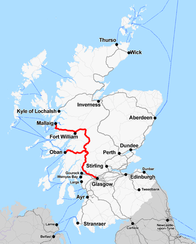
English: Railway map of Scotland showing the West Highland line |
| Ji̍t-kî | |
| Chhut-chhù | Ka-tī chò--ê |
| Chok-chiá | Cnbrb |
| 描寫 |
This map was created from OpenStreetMap project data, collected by the community. This map may be incomplete, and may contain errors. Don't rely solely on it for navigation. |
|||
| Ji̍t-kî | (see file history) | |||
| Chhut-chhù | openstreetmap.org | |||
| 創作作者 |
OpenStreetMap contributors |
|||
| Siū-khuân ún-tsún (Koh iōng tsit-ê tóng-àn) |
OpenStreetMap data is available under the Open Database License (details). Map tiles are licensed under the Creative Commons Attribution-ShareAlike 2.0 license (CC-BY-SA 2.0).
此檔案採用創用CC 姓名標示-相同方式分享 2.0 通用版授權條款。
|
|||
| 地理參考 | 如果不合適,請設定「warp_status = skip」為隱藏。 |
Siū-khoân
我,本作品的著作權持有者,決定用以下授權條款發佈本作品:
| 此檔案在創用CC CC0 1.0 通用公有領域貢獻宣告之下分發。 | |
| 在此宣告之下分發本作品者,已依據各國著作權法,在全世界放棄其對本作品所擁有的著作權及所有相關相似的法律權利,從而將本作品貢獻至公有領域。您可以複製、修改、分發和演示該作品,用於任何商業用途,所有這些都不需要請求授權。
|
檔案歷史
揤日期/時間,看彼時陣的檔案.
| 日期/ 時間 | 細張圖 | 寸尺 | 用者 | 註解 | |
|---|---|---|---|---|---|
| 現在 | 2015年7月4日 (拜6) 22:52 | | 1,349 × 1,683(383 KB) | wikimediacommons>Cmdrjameson | Compressed with pngout. Reduced by 289kB (43% decrease). |
影像連結
以下的頁連到這个影像: