tóng-àn:St Mary's, Turweston - geograph.org.uk - 143152.jpg
跳至導覽
跳至搜尋
無較權的解析度.
St_Mary's,_Turweston_-_geograph.org.uk_-_143152.jpg (640 × 427 像素,檔案佔量: 119 KB,MIME類型: image/jpeg)
|
|
這是對Wikimedia Commons引來的一份檔案。伊佇hia ê kì-su̍t-ia̍h頂面的資訊顯示對下底. |
This is a photo of listed building number 1289451. |
Khài-iàu
| Soat-bêng |
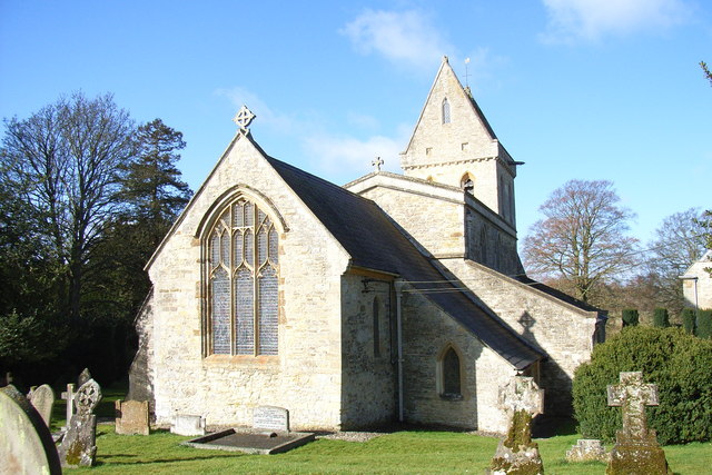
English: Parish church of the Assumption of the blesséd Virgin Mary, Turweston, Buckinghamshire, seen from the east |
| Ji̍t-kî | |
| Chhut-chhù | From geograph.org.uk |
| Chok-chiá | Andrew Smith |
| Piau-sī miâ-sìnn (由许可协议要求) | Andrew Smith / St Mary's, Turweston / |
| 目標地點 | | 位於此地的本圖片與其他圖片: OpenStreetMap |
|---|
_&language=nan)
Siū-khoân

|
此檔案採用創用CC 姓名標示-相同方式分享 2.0 通用版授權條款。
Piau-sī miâ-sìnn: Andrew Smith
- Lí ē-sái tsū-iû:
- hun-hióng – kho͘-pih, hoat-pò͘ kap thoân-pò͘ pún chok
- tiông-sin siu-kái – kái-pian pún chok-phín
- Àn i-hā ê tiâu-kiāⁿ
- Piau-sī miâ-sìnn – Lí ài siá-bîng tsìng-khak ê miâ-hō, ū siū-khuân tiâu-khuán ê liân-kiat, iáu-koh-ū lí tsuè siánn-mih ê kái-piàn. Lí ē-tàng tī jīm-hô ha̍p-lí ê hong-sik tsìn-hîng, m̄-kò buē-tàng ti̍t-tsiap kóng siū-khuân hōo lí ia̍h-sī lí sú-iōng.
- Kâng-khuán hong-sik hun-hióng – Lí nā kái-tōng, piàn-khoán, he̍k-chiá kun-kù pún chok chhòng-chō, lí kaⁿ-taⁿ ē-tàng ēng kap pún chok kâng-khoán he̍k-chiá saⁿ-chhiūⁿ ê hí-khó lâi hoat-pò͘ chò--chhut-lâi ê chok-phín.
檔案歷史
揤日期/時間,看彼時陣的檔案.
| 日期/ 時間 | 細張圖 | 寸尺 | 用者 | 註解 | |
|---|---|---|---|---|---|
| 現在 | 2010年1月31日 (禮拜) 09:50 | | 640 × 427(119 KB) | wikimediacommons>GeographBot | == {{int:filedesc}} == {{Information |description={{en|1=St Mary's, Turweston. A tower with a triangular cap is a feature of many North Buckinghamshire and, particularly, Northamptonshire churches.}} |date=2006-03-25 |source=From [http://www.geograph.org. |
影像連結
以下的頁連到這个影像: