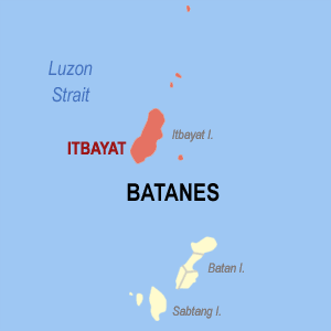
Itbayat

Lohankhapedia (自由的百科全書) 欲共你講..。
跳至導覽 跳至搜尋
Ph locator batanes itbayat.png

Itbayat ()菲律賓 (Hui-li̍p-pin)Batanes (séng)下底 (ē-té) (ê)行政區 (hêng-chèng-khu)伊的 (i-ê) (chú) ()Itbayat島 ()是省 (lāi) (siāng) (tōa)島嶼 (tó-sū)所在 (só͘-chāi) ()菲律賓 (oa̍h) (pak) ()台灣 (Tâi-oân)大約 (tāi-iok)200公里 (kong-lí)

Itbayat的人口 (jîn-kháu) (ū)2,867 (lâng)面積 (biān-chek)83.13平方 (pêng-hong)公里。 Itbayat (só͘) (koán)的島嶼除了 (tû-liáu)主島, ()DiogoSiayanMaysangaMabudisNorth (kap)Mavulis (嘛 (kiò)Y'ami), (in)是菲律賓 (siān)活北的群島 (kûn-tó)

歷史 (Le̍k-sú)[修改]

佇Itbayat島的Torongan佮Reranum的山洞 (soaⁿ-tōng),有發見 (hoat-kiàn)大概 (tāi-kài)3000 (kàu)4000 () (chêng)遺蹟 (ûi-chek)[1]

參考 (Chham-khó)[修改]

  1. Peter Bellwood, Eusebio Dizon and Armand Mijares (2013). "Archaeological Excavations on Itbayat and Siayan Islands". 4000 Years of Migration and Cultural Exchange. ANU E Press.