tóng-àn:Europäische Wasserscheiden.png
Lohankhapedia (自由的百科全書) 欲共你講..。
跳至導覽
跳至搜尋

先看佔量: 608 × 600 像素. 其他的 kái-sek-tō͘: 243 × 240 像素 | 486 × 480 像素 | 778 × 768 像素 | 1,200 × 1,184 像素.
全解析度 (1,200 × 1,184 像素,檔案佔量: 526 KB,MIME類型: image/png)
|
|
這是對Wikimedia Commons引來的一份檔案。伊佇hia ê kì-su̍t-ia̍h頂面的資訊顯示對下底. |
Khài-iàu
| Soat-bêngEuropäische Wasserscheiden.png |
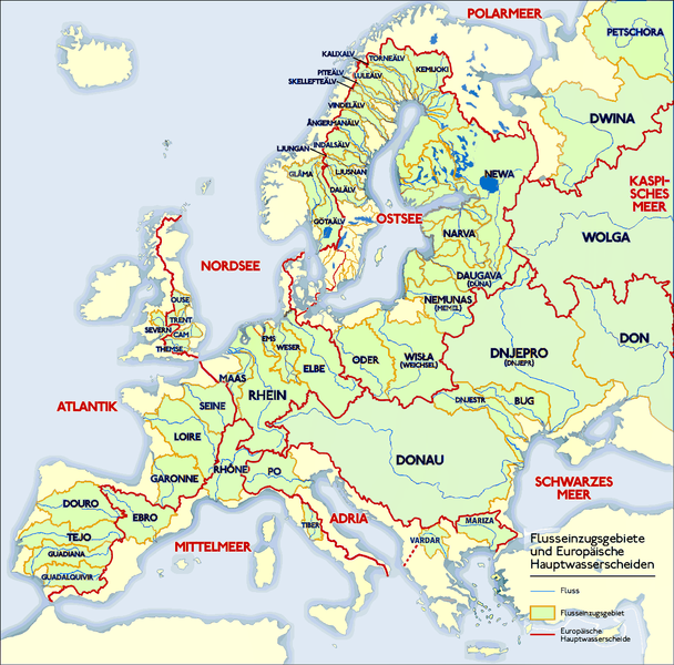
Deutsch: Grafik zeigt die Europäischen Flusseinzugsgebiete und Hauptwasserscheiden.
Zeichnung erstellt 06/2004 von Sansculotte. Bild ist unter der Creative Commons Share Alike zur weiteren Verwendung freigegeben. Quellenangabe und Beleg an sansculotte@despammed.com erbeten.English: The map shows the European rivers' catchment areas and main watersheds.
Chart made on 06/2004 by de:Sansculotte. The image is released under the Creative Commons Share Alike license for futher use. Reference and sources can be requested from sansculotte@despammed.comFrançais : Carte des bassins fluviaux d'Europe. Carte établie en juin 2004 par le contributeur de:Sansculotte
Sources (!) disponibles par demande à sansculotte@despammed.com
|
||||||||
| Ji̍t-kî | |||||||||
| Chhut-chhù | Source: German Wikipedia, original upload see file history | ||||||||
| Chok-chiá | Sansculotte | ||||||||
| Siū-khuân ún-tsún (Koh iōng tsit-ê tóng-àn) |
此檔案採用創用CC 姓名標示-相同方式分享 2.0 通用版授權條款。
|
||||||||
| 其他版本 |
Derivative works of this file:
|
|
File history German Wikipedia
(Löschen) (Aktuell) 16:54, 15. Jan 2005 . . Sansculotte . . 1200x1184 (602233 Byte) (korr.)
(Löschen) (Zurücksetzen) 05:01, 3. Jun 2004 . . Sansculotte . . 1000x987 (262710 Byte) (eigene Darstellung, GNU FDL, Europäische Flußeinzugsgebiete und Hauptwasserscheiden)
(Löschen) (Zurücksetzen) 04:21, 3. Jun 2004 . . Sansculotte . . 1000x987 (183238 Byte) (eigene Darstellung, GNU FDL, Europäische Flußeinzugsgebiete und Hauptwasserscheiden)
說明
添加單行說明來描述出檔案所代表的內容
The main rivers of Europe and their catchment areas.
授權條款 繁體中文
多媒體型式 繁體中文
image/png
檔案歷史
揤日期/時間,看彼時陣的檔案.
| 日期/ 時間 | 細張圖 | 寸尺 | 用者 | 註解 | |
|---|---|---|---|---|---|
| 現在 | 2019年7月31日 (拜3) 08:45 |  | 1,200 × 1,184(526 KB) | wikimediacommons>1970gemini | entschleiert |
影像連結
以下的頁連到這个影像:

