tóng-àn:Labrador-Peninsula.PNG
跳至導覽
跳至搜尋
無較權的解析度.
Labrador-Peninsula.PNG (280 × 230 像素,檔案佔量: 14 KB,MIME類型: image/png)
|
|
這是對Wikimedia Commons引來的一份檔案。伊佇hia ê kì-su̍t-ia̍h頂面的資訊顯示對下底. |
Khài-iàu
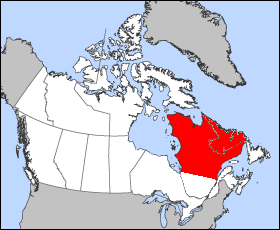
| Soat-bêng | Illustration of the approximate geographic area of the Labrador Peninsula. Modification of "en.wikipedia.org/wiki/Image:Quebec-map.png" |
| Ji̍t-kî | 2005年12-goe̍h25日 (原始上傳日期) |
| Chhut-chhù | No machine-readable source provided. Own work assumed (based on copyright claims). |
| Chok-chiá | No machine-readable author provided. Joseph B~commonswiki assumed (based on copyright claims). |
Siū-khoân
| 我,此作品的版權所有人,釋出此作品至公共領域。此授權條款在全世界均適用。 這可能在某些國家不合法,如果是的話: 我授予任何人有權利使用此作品於任何用途,除受法律約束外,不受任何限制。 |
檔案歷史
揤日期/時間,看彼時陣的檔案.
| 日期/ 時間 | 細張圖 | 寸尺 | 用者 | 註解 | |
|---|---|---|---|---|---|
| 現在 | 2005年12月26日 (拜1) 04:46 | | 280 × 230(14 KB) | Joseph B~commonswiki | Illustration of the approximate geographic area of the Labrador Peninsula. Modification of "en.wikipedia.org/wiki/Image:Quebec-map.png" |
影像連結
以下的頁連到這个影像: